Silver End geodata
Silver End (England) is a populated place; located in United Kingdom in Europe/London (GMT+1) time zone. With population of 3,861 people, there are 1880 cities with bigger population in this country. Compared to other cities in United Kingdom, 66.6% of cities are located further ↑North; 93.5% of cities are located further ←West and 56.8% of cities have higher elevation than Silver End. Note1
Administrative division(s):
- Level 1: England
- Level 2: Essex
- Level 3: Braintree District
- Level 4: Silver End


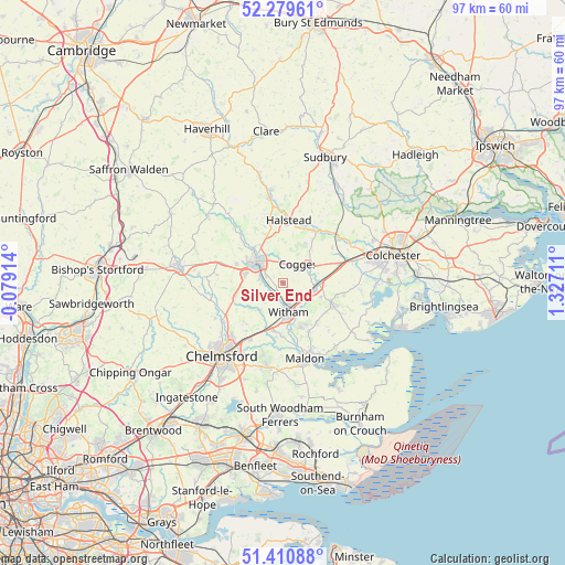
Silver End GPS coordinates[2]
51° 50' 50.424" North, 0° 37' 26.364" East
| Map corner | latitude | longitude |
|---|---|---|
| Upper-left | 52.27961°, | -0.07914° |
| Center: | 51.84734°, | 0.62399° |
| Lower-right: | 51.41088°, | 1.32711° |
| Map W x H: | 96.6×96.6 km | = 60×60mi |
| max Lat: | 60.39635° ⇑66.6% North |
| Silver End: | 51.84734° |
| min Lat: | ⇓33.4% South 34.60088° |
| min Long | Silver End | max Long |
| -7.64133° | 0.62399° | 32.95536° |
| W 93.5%⇐ | ⇒6.5% E |
Elevation
Elevation of Silver End is 51 m = 167 ft, and this is 21.9 m = 72 ft below average elevation for this country.
| Max E: |
515 m = 1690 ft | 56.8% |
| Avg. | 72.9 m = 239 ft | |
| Silver End | 51 m = 167 ft | |
Min E: |
-30 m = -98 ft | 43.2% |
See also: United Kingdom elevation on elevation.city.
Geographical zone
Silver End is located in North temperate zone (between Tropic of Cancer and the Arctic Circle). Distance of this North polar circle is 1636.3 km =1016.7 mi to North.| Distance of | km | miles | from Silver End |
|---|---|---|---|
| North Pole | 4242.2 | 2636 | to North |
| Arctic Circle | 1636.3 | 1016.7 | to North |
| Tropic Cancer | 3159 | 1962.9 | to South |
| Equator | 5764.9 | 3582.1 | to South |


Nearby cities:
15 places around Silver End: (largest is in red/bold)
• Black Notley
3.9 km =2.4 mi,  279°
279°
• Braintree
6 km =3.7 mi,  305°
305°
• Coggeshall
5 km =3.1 mi,  58°
58°
• Gosfield
10.2 km =6.3 mi,  347°
347°
• Great Leighs
8.4 km =5.2 mi,  254°
254°
• Great Tey
10.3 km =6.4 mi, 56°
• Great Totham
9.1 km =5.7 mi,  138°
138°
• Hatfield Peverel
8.2 km =5.1 mi,  194°
194°
• Kelvedon
5.7 km =3.5 mi,  98°
98°
• Marks Tey
10.2 km =6.3 mi,  71°
71°
• Panfield
9.1 km =5.7 mi, 308°
• Rayne
3.5 km =2.2 mi, 307°
• Tiptree
9.2 km =5.7 mi,  115°
115°
• Wickham Bishops
8.3 km =5.2 mi,  158°
158°
• Witham
5.4 km =3.4 mi,  167°
167°
Sources, notices
• [Note1] Compared only with cities in United Kingdom existing in our database
• [Src1] Map data: © OpenStreetMap contributors (CC-BY-SA)
• [Src2] Other city data from geonames.org with taken over terms of usage.
• [Src3] Geographical zone / Annual Mean Temperature by Robert A. Rohde @ Wikipedia
