Bradfield geodata
Bradfield (England) is a populated place; located in United Kingdom in Europe/London (GMT+1) time zone. With population of 1,161 people, there are 3409 cities with bigger population in this country. Compared to other cities in United Kingdom, 79.4% of cities are located further ↑North; 64.2% of cities are located further ←West and 55.3% of cities have lower elevation than Bradfield. Note1


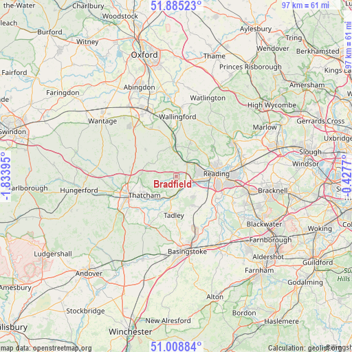
Bradfield GPS coordinates[2]
51° 26' 56.904" North, 1° 7' 50.952" West
| Map corner | latitude | longitude |
|---|---|---|
| Upper-left | 51.88523°, | -1.83395° |
| Center: | 51.44914°, | -1.13082° |
| Lower-right: | 51.00884°, | -0.4277° |
| Map W x H: | 97.4×97.4 km | = 60.5×60.5mi |
| max Lat: | 60.39635° ⇑79.4% North |
| Bradfield: | 51.44914° |
| min Lat: | ⇓20.6% South 34.60088° |
| min Long | Bradfield | max Long |
| -7.64133° | -1.13082° | 32.95536° |
| W 64.2%⇐ | ⇒35.8% E |
Elevation
Elevation of Bradfield is 69 m = 226 ft, and this is 3.9 m = 13 ft below average elevation for this country.
| Max E: |
515 m = 1690 ft | 44.7% |
| Avg. | 72.9 m = 239 ft | |
| Bradfield | 69 m = 226 ft | |
Min E: |
-30 m = -98 ft | 55.3% |
See also: United Kingdom elevation on elevation.city.
Geographical zone
Bradfield is located in North temperate zone (between Tropic of Cancer and the Arctic Circle). Distance of this North polar circle is 1680.6 km =1044.3 mi to North.| Distance of | km | miles | from Bradfield |
|---|---|---|---|
| North Pole | 4286.5 | 2663.5 | to North |
| Arctic Circle | 1680.6 | 1044.3 | to North |
| Tropic Cancer | 3114.7 | 1935.4 | to South |
| Equator | 5720.6 | 3554.6 | to South |


Nearby cities:
15 places around Bradfield: (largest is in red/bold)
• Beenham
3.8 km =2.4 mi,  197°
197°
• Calcot
5.6 km =3.5 mi,  99°
99°
• Cold Ash
9.7 km =6 mi,  253°
253°
• Goring
8.2 km =5.1 mi,  358°
358°
• Hampstead Norreys
8.5 km =5.3 mi,  296°
296°
• Hermitage
9.5 km =5.9 mi,  274°
274°
• Pangbourne
5 km =3.1 mi,  39°
39°
• Reading
11.1 km =6.9 mi,  85°
85°
• Silchester
10.8 km =6.7 mi,  168°
168°
• Stratfield Mortimer
10.7 km =6.6 mi,  141°
141°
• Tadley
11 km =6.8 mi,  179°
179°
• Thatcham
10.3 km =6.4 mi,  240°
240°
• Theale
4 km =2.5 mi,  109°
109°
• Tilehurst
6.1 km =3.8 mi,  82°
82°
• Upper Basildon
3.7 km =2.3 mi,  349°
349°
Sources, notices
• [Note1] Compared only with cities in United Kingdom existing in our database
• [Src1] Map data: © OpenStreetMap contributors (CC-BY-SA)
• [Src2] Other city data from geonames.org with taken over terms of usage.
• [Src3] Geographical zone / Annual Mean Temperature by Robert A. Rohde @ Wikipedia
