Boston geodata
Boston (England) is a populated place; located in United Kingdom in Europe/London (GMT+1) time zone. With population of 41,340 people, there are 292 cities with bigger population in this country. Compared to other cities in United Kingdom, 60.3% of cities are located further ↓South; 86% of cities are located further ←West and 93.6% of cities have higher elevation than Boston. Note1


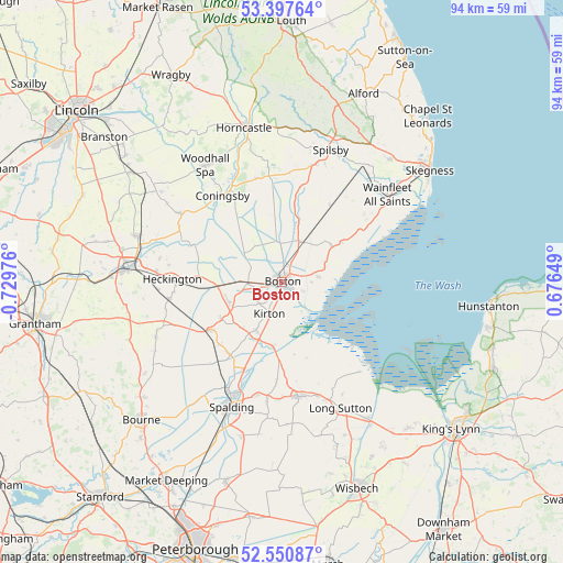
Boston GPS coordinates[2]
52° 58' 34.788" North, 0° 1' 35.904" West
| Map corner | latitude | longitude |
|---|---|---|
| Upper-left | 53.39764°, | -0.72976° |
| Center: | 52.97633°, | -0.02664° |
| Lower-right: | 52.55087°, | 0.67649° |
| Map W x H: | 94.2×94.2 km | = 58.5×58.5mi |
| max Lat: | 60.39635° ⇑39.7% North |
| Boston: | 52.97633° |
| min Lat: | ⇓60.3% South 34.60088° |
| min Long | Boston | max Long |
| -7.64133° | -0.02664° | 32.95536° |
| W 86%⇐ | ⇒14% E |
Elevation
Elevation of Boston is 9 m = 30 ft, and this is 63.9 m = 210 ft below average elevation for this country.
| Max E: |
515 m = 1690 ft | 93.6% |
| Avg. | 72.9 m = 239 ft | |
| Boston | 9 m = 30 ft | |
Min E: |
-30 m = -98 ft | 6.4% |
See also: Boston elevation on elevation.city.
Geographical zone
Boston is located in North temperate zone (between Tropic of Cancer and the Arctic Circle). Distance of this North polar circle is 1510.8 km =938.8 mi to North.| Distance of | km | miles | from Boston |
|---|---|---|---|
| North Pole | 4116.6 | 2557.9 | to North |
| Arctic Circle | 1510.8 | 938.8 | to North |
| Tropic Cancer | 3284.5 | 2040.9 | to South |
| Equator | 5890.4 | 3660.1 | to South |


Nearby cities:
15 places around Boston: (largest is in red/bold)
• Bicker
11.9 km =7.4 mi,  239°
239°
• Butterwick
6.3 km =3.9 mi,  82°
82°
• Coningsby
17.5 km =10.9 mi,  325°
325°
• Donington
14.4 km =8.9 mi, 236°
• Fishtoft
4 km =2.5 mi,  115°
115°
• Gosberton
14.9 km =9.3 mi,  217°
217°
• Holbeach Clough
16.9 km =10.5 mi,  176°
176°
• Kirton
5.8 km =3.6 mi,  202°
202°
• Old Leake
10.4 km =6.5 mi,  54°
54°
• Quadring
14.8 km =9.2 mi,  225°
225°
• Sibsey
7.5 km =4.7 mi,  22°
22°
• Stickney
12.8 km =8 mi,  9°
9°
• Sutterton
9.3 km =5.8 mi,  208°
208°
• Swineshead
9.5 km =5.9 mi,  248°
248°
• Wrangle
12.6 km =7.8 mi,  56°
56°
Sources, notices
• [Note1] Compared only with cities in United Kingdom existing in our database
• [Src1] Map data: © OpenStreetMap contributors (CC-BY-SA)
• [Src2] Other city data from geonames.org with taken over terms of usage.
• [Src3] Geographical zone / Annual Mean Temperature by Robert A. Rohde @ Wikipedia
