Bolton geodata
Bolton (England) is a seat of a second-order administrative division; located in United Kingdom in Europe/London (GMT+1) time zone. With population of 141,331 people, there are 67 cities with bigger population in this country. Compared to other cities in United Kingdom, 71.6% of cities are located further ↓South; 63.7% of cities are located further →East and 74.6% of cities have lower elevation than Bolton. Note1


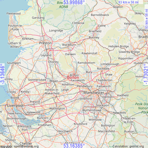
Bolton GPS coordinates[2]
53° 34' 59.988" North, 2° 25' 59.988" West
| Map corner | latitude | longitude |
|---|---|---|
| Upper-left | 53.99868°, | -3.13646° |
| Center: | 53.58333°, | -2.43333° |
| Lower-right: | 53.16385°, | -1.73021° |
| Map W x H: | 92.8×92.8 km | = 57.7×57.7mi |
| max Lat: | 60.39635° ⇑28.4% North |
| Bolton: | 53.58333° |
| min Lat: | ⇓71.6% South 34.60088° |
| min Long | Bolton | max Long |
| -7.64133° | -2.43333° | 32.95536° |
| W 36.3%⇐ | ⇒63.7% E |
Elevation
Elevation of Bolton is 105 m = 344 ft, and this is 32.1 m = 105 ft above average elevation for this country.
| Max E: |
515 m = 1690 ft | 25.4% |
| Bolton | 105 m 344 ft | |
| Avg. | 72.9 m = 239 ft | |
Min E: |
-30 m = -98 ft | 74.6% |
See also: Bolton elevation on elevation.city.
Geographical zone
Bolton is located in North temperate zone (between Tropic of Cancer and the Arctic Circle). Distance of this North polar circle is 1443.3 km =896.8 mi to North.| Distance of | km | miles | from Bolton |
|---|---|---|---|
| North Pole | 4049.2 | 2516.1 | to North |
| Arctic Circle | 1443.3 | 896.8 | to North |
| Tropic Cancer | 3352 | 2082.8 | to South |
| Equator | 5957.9 | 3702.1 | to South |


Nearby cities:
15 places around Bolton: (largest is in red/bold)
• Atherton
7.7 km =4.8 mi,  210°
210°
• Bury
9 km =5.6 mi,  78°
78°
• Edgworth
7.5 km =4.7 mi,  20°
20°
• Farnworth
4.3 km =2.7 mi,  149°
149°
• Horwich
7.9 km =4.9 mi,  284°
284°
• Kearsley
6.5 km =4 mi, 149°
• Little Hulton
5.7 km =3.5 mi,  168°
168°
• Little Lever
4.3 km =2.7 mi,  121°
121°
• Lostock
4.6 km =2.9 mi,  263°
263°
• Radcliffe
7.6 km =4.7 mi,  108°
108°
• Tottington
7 km =4.3 mi,  61°
61°
• Tyldesley
8 km =5 mi,  196°
196°
• Walkden
7.7 km =4.8 mi,  163°
163°
• Westhoughton
7.1 km =4.4 mi,  237°
237°
• Whitefield
9.6 km =6 mi, 112°
Sources, notices
• [Note1] Compared only with cities in United Kingdom existing in our database
• [Src1] Map data: © OpenStreetMap contributors (CC-BY-SA)
• [Src2] Other city data from geonames.org with taken over terms of usage.
• [Src3] Geographical zone / Annual Mean Temperature by Robert A. Rohde @ Wikipedia
