Bury geodata
Bury (England) is a seat of a second-order administrative division; located in United Kingdom in Europe/London (GMT+0) time zone. With population of 61,044 people, there are 178 cities with bigger population in this country. Compared to other cities in United Kingdom, 71.9% of cities are located further ↓South; 61.3% of cities are located further →East and 68.6% of cities have lower elevation than Bury. Note1


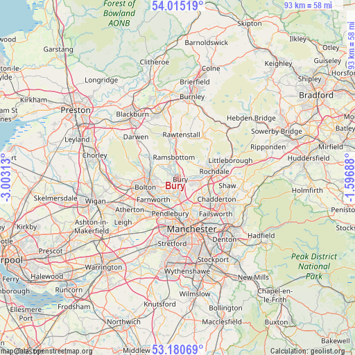
Bury GPS coordinates[2]
53° 36' 0" North, 2° 18' 0" West
| Map corner | latitude | longitude |
|---|---|---|
| Upper-left | 54.01519°, | -3.00313° |
| Center: | 53.6°, | -2.3° |
| Lower-right: | 53.18069°, | -1.59688° |
| Map W x H: | 92.8×92.8 km | = 57.7×57.7mi |
| max Lat: | 60.39635° ⇑28.1% North |
| Bury: | 53.6° |
| min Lat: | ⇓71.9% South 34.60088° |
| min Long | Bury | max Long |
| -7.64133° | -2.3° | 32.95536° |
| W 38.7%⇐ | ⇒61.3% E |
Elevation
Elevation of Bury is 93 m = 305 ft, and this is 20.1 m = 66 ft above average elevation for this country.
| Max E: |
515 m = 1690 ft | 31.4% |
| Bury | 93 m 305 ft | |
| Avg. | 72.9 m = 239 ft | |
Min E: |
-30 m = -98 ft | 68.6% |
See also: Bury elevation on elevation.city.
Geographical zone
Bury is located in North temperate zone (between Tropic of Cancer and the Arctic Circle). Distance of this North polar circle is 1441.4 km =895.6 mi to North.| Distance of | km | miles | from Bury |
|---|---|---|---|
| North Pole | 4047.3 | 2514.9 | to North |
| Arctic Circle | 1441.4 | 895.6 | to North |
| Tropic Cancer | 3353.8 | 2084 | to South |
| Equator | 5959.8 | 3703.2 | to South |


Nearby cities:
15 places around Bury: (largest is in red/bold)
• Bolton
9 km =5.6 mi,  258°
258°
• Edenfield
7.4 km =4.6 mi,  357°
357°
• Edgworth
8.1 km =5 mi,  309°
309°
• Farnworth
8.6 km =5.3 mi,  229°
229°
• Heywood
5.4 km =3.4 mi,  98°
98°
• Kearsley
9.2 km =5.7 mi,  216°
216°
• Little Lever
6.6 km =4.1 mi, 231°
• Middleton
8.6 km =5.3 mi,  130°
130°
• Prestwich
7.5 km =4.7 mi,  171°
171°
• Radcliffe
4.5 km =2.8 mi,  200°
200°
• Ramsbottom
5.4 km =3.4 mi,  348°
348°
• Rossendale
9.5 km =5.9 mi,  9°
9°
• Simister
6.4 km =4 mi,  152°
152°
• Tottington
3.1 km =1.9 mi,  298°
298°
• Whitefield
5.6 km =3.5 mi,  180°
180°
Sources, notices
• [Note1] Compared only with cities in United Kingdom existing in our database
• [Src1] Map data: © OpenStreetMap contributors (CC-BY-SA)
• [Src2] Other city data from geonames.org with taken over terms of usage.
• [Src3] Geographical zone / Annual Mean Temperature by Robert A. Rohde @ Wikipedia
