Bath geodata
Bath (England) is a seat of a second-order administrative division; located in United Kingdom in Europe/London (GMT+0) time zone. With population of 94,782 people, there are 103 cities with bigger population in this country. Compared to other cities in United Kingdom, 81.7% of cities are located further ↑North; 62.5% of cities are located further →East and 70.3% of cities have lower elevation than Bath. Note1


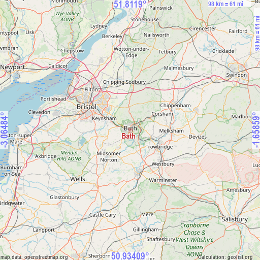
Bath GPS coordinates[2]
51° 22' 30.36" North, 2° 21' 42.192" West
| Map corner | latitude | longitude |
|---|---|---|
| Upper-left | 51.8119°, | -3.06484° |
| Center: | 51.3751°, | -2.36172° |
| Lower-right: | 50.93409°, | -1.65859° |
| Map W x H: | 97.6×97.6 km | = 60.6×60.6mi |
| max Lat: | 60.39635° ⇑81.7% North |
| Bath: | 51.3751° |
| min Lat: | ⇓18.3% South 34.60088° |
| min Long | Bath | max Long |
| -7.64133° | -2.36172° | 32.95536° |
| W 37.5%⇐ | ⇒62.5% E |
Elevation
Elevation of Bath is 96 m = 315 ft, and this is 23.1 m = 76 ft above average elevation for this country.
| Max E: |
515 m = 1690 ft | 29.7% |
| Bath | 96 m 315 ft | |
| Avg. | 72.9 m = 239 ft | |
Min E: |
-30 m = -98 ft | 70.3% |
See also: Bath elevation on elevation.city.
Geographical zone
Bath is located in North temperate zone (between Tropic of Cancer and the Arctic Circle). Distance of this North polar circle is 1688.8 km =1049.4 mi to North.| Distance of | km | miles | from Bath |
|---|---|---|---|
| North Pole | 4294.7 | 2668.6 | to North |
| Arctic Circle | 1688.8 | 1049.4 | to North |
| Tropic Cancer | 3106.5 | 1930.3 | to South |
| Equator | 5712.4 | 3549.5 | to South |


Nearby cities:
15 places around Bath: (largest is in red/bold)
• Bathford
5 km =3.1 mi,  56°
56°
• Bitton
8.8 km =5.5 mi,  309°
309°
• Bradford-on-Avon
8.3 km =5.2 mi,  111°
111°
• Cold Ashton
8.4 km =5.2 mi,  0°
0°
• Corston
5.6 km =3.5 mi,  281°
281°
• Freshford
5.7 km =3.5 mi,  134°
134°
• Hinton Charterhouse
6.2 km =3.9 mi,  157°
157°
• Limpley Stoke
4.7 km =2.9 mi,  135°
135°
• Monkton Farleigh
5.8 km =3.6 mi,  75°
75°
• Norton St Philip
8.5 km =5.3 mi, 162°
• Peasedown Saint John
7.8 km =4.8 mi,  213°
213°
• Priston
6.5 km =4 mi,  236°
236°
• Saltford
7.4 km =4.6 mi,  293°
293°
• Wellow
5.7 km =3.5 mi,  188°
188°
• Westwood
7.3 km =4.5 mi, 128°
Sources, notices
• [Note1] Compared only with cities in United Kingdom existing in our database
• [Src1] Map data: © OpenStreetMap contributors (CC-BY-SA)
• [Src2] Other city data from geonames.org with taken over terms of usage.
• [Src3] Geographical zone / Annual Mean Temperature by Robert A. Rohde @ Wikipedia
