Barnet geodata
Barnet (England) is a populated place; located in United Kingdom in Europe/London (GMT+1) time zone. With population of 30,000 people, there are 407 cities with bigger population in this country. Compared to other cities in United Kingdom, 72.7% of cities are located further ↑North; 82.9% of cities are located further ←West and 79.7% of cities have lower elevation than Barnet. Note1


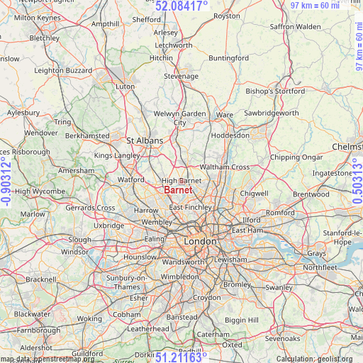
Barnet GPS coordinates[2]
51° 39' 0" North, 0° 12' 0" West
| Map corner | latitude | longitude |
|---|---|---|
| Upper-left | 52.08417°, | -0.90312° |
| Center: | 51.65°, | -0.2° |
| Lower-right: | 51.21163°, | 0.50313° |
| Map W x H: | 97×97 km | = 60.3×60.3mi |
| max Lat: | 60.39635° ⇑72.7% North |
| Barnet: | 51.65° |
| min Lat: | ⇓27.3% South 34.60088° |
| min Long | Barnet | max Long |
| -7.64133° | -0.2° | 32.95536° |
| W 82.9%⇐ | ⇒17.1% E |
Elevation
Elevation of Barnet is 117 m = 384 ft, and this is 44.1 m = 145 ft above average elevation for this country.
| Max E: |
515 m = 1690 ft | 20.3% |
| Barnet | 117 m 384 ft | |
| Avg. | 72.9 m = 239 ft | |
Min E: |
-30 m = -98 ft | 79.7% |
See also: United Kingdom elevation on elevation.city.
Geographical zone
Barnet is located in North temperate zone (between Tropic of Cancer and the Arctic Circle). Distance of this North polar circle is 1658.2 km =1030.4 mi to North.| Distance of | km | miles | from Barnet |
|---|---|---|---|
| North Pole | 4264.1 | 2649.6 | to North |
| Arctic Circle | 1658.2 | 1030.4 | to North |
| Tropic Cancer | 3137 | 1949.2 | to South |
| Equator | 5742.9 | 3568.5 | to South |


Nearby cities:
15 places around Barnet: (largest is in red/bold)
• Borehamwood
5.4 km =3.4 mi,  275°
275°
• Cuffley
8.8 km =5.5 mi,  43°
43°
• Edgware
6.6 km =4.1 mi,  231°
231°
• Elstree
6.8 km =4.2 mi,  260°
260°
• Enfield Town
7.9 km =4.9 mi,  88°
88°
• Hadley Wood
2.8 km =1.7 mi,  48°
48°
• Hendon
5.7 km =3.5 mi,  191°
191°
• High Barnet
0.9 km =0.6 mi,  322°
322°
• Northaw
6.9 km =4.3 mi,  31°
31°
• Potters Bar
5.1 km =3.2 mi,  17°
17°
• Radlett
9.1 km =5.7 mi,  296°
296°
• Shenley
7.2 km =4.5 mi,  309°
309°
• South Mimms
5.6 km =3.5 mi,  336°
336°
• Stanmore
8.9 km =5.5 mi,  245°
245°
• Wood Green
8 km =5 mi,  134°
134°
In other languages:
- In Spanish: Municipio de Barnet
- In German: London Borough of Barnet
- In Russian: Барнет
- In Chinese: 巴尼特區
Sources, notices
• [Note1] Compared only with cities in United Kingdom existing in our database
• [Src1] Map data: © OpenStreetMap contributors (CC-BY-SA)
• [Src2] Other city data from geonames.org with taken over terms of usage.
• [Src3] Geographical zone / Annual Mean Temperature by Robert A. Rohde @ Wikipedia
