Hadley Wood geodata
Hadley Wood (England) is a populated place; located in United Kingdom in Europe/London (GMT+1) time zone. With population of 21,639 people, there are 547 cities with bigger population in this country. Compared to other cities in United Kingdom, 72.1% of cities are located further ↑North; 83.5% of cities are located further ←West and 74.2% of cities have lower elevation than Hadley Wood. Note1


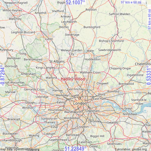
Hadley Wood GPS coordinates[2]
51° 40' 0.084" North, 0° 10' 11.316" West
| Map corner | latitude | longitude |
|---|---|---|
| Upper-left | 52.1007°, | -0.87294° |
| Center: | 51.66669°, | -0.16981° |
| Lower-right: | 51.22849°, | 0.53331° |
| Map W x H: | 97×97 km | = 60.3×60.3mi |
| max Lat: | 60.39635° ⇑72.1% North |
| Hadley Wood: | 51.66669° |
| min Lat: | ⇓27.9% South 34.60088° |
| min Long | Hadley Wood | max Long |
| -7.64133° | -0.16981° | 32.95536° |
| W 83.5%⇐ | ⇒16.5% E |
Elevation
Elevation of Hadley Wood is 104 m = 341 ft, and this is 31.1 m = 102 ft above average elevation for this country.
| Max E: |
515 m = 1690 ft | 25.8% |
| Hadley Wood | 104 m 341 ft | |
| Avg. | 72.9 m = 239 ft | |
Min E: |
-30 m = -98 ft | 74.2% |
See also: United Kingdom elevation on elevation.city.
Geographical zone
Hadley Wood is located in North temperate zone (between Tropic of Cancer and the Arctic Circle). Distance of this North polar circle is 1656.4 km =1029.2 mi to North.| Distance of | km | miles | from Hadley Wood |
|---|---|---|---|
| North Pole | 4262.3 | 2648.5 | to North |
| Arctic Circle | 1656.4 | 1029.2 | to North |
| Tropic Cancer | 3138.9 | 1950.4 | to South |
| Equator | 5744.8 | 3569.7 | to South |


Nearby cities:
15 places around Hadley Wood: (largest is in red/bold)
• Barnet
2.8 km =1.7 mi,  228°
228°
• Borehamwood
7.6 km =4.7 mi,  259°
259°
• Crouch End
10.2 km =6.3 mi,  161°
161°
• Cuffley
6.1 km =3.8 mi,  40°
40°
• Edgware
9.4 km =5.8 mi, 230°
• Elstree
9.2 km =5.7 mi,  251°
251°
• Enfield Town
6.1 km =3.8 mi,  106°
106°
• Hendon
8.1 km =5 mi,  203°
203°
• High Barnet
2.9 km =1.8 mi, 245°
• Northaw
4.4 km =2.7 mi,  20°
20°
• Potters Bar
3 km =1.9 mi,  348°
348°
• Shenley
8.1 km =5 mi,  289°
289°
• South Mimms
5.4 km =3.4 mi,  306°
306°
• Waltham Cross
9.5 km =5.9 mi,  76°
76°
• Wood Green
8.3 km =5.2 mi,  153°
153°
Sources, notices
• [Note1] Compared only with cities in United Kingdom existing in our database
• [Src1] Map data: © OpenStreetMap contributors (CC-BY-SA)
• [Src2] Other city data from geonames.org with taken over terms of usage.
• [Src3] Geographical zone / Annual Mean Temperature by Robert A. Rohde @ Wikipedia
