Bangor geodata
Bangor (Northern Ireland) is a seat of a second-order administrative division; located in United Kingdom in Europe/London (GMT+0) time zone. With population of 60,385 people, there are 182 cities with bigger population in this country. Compared to other cities in United Kingdom, 83.7% of cities are located further ↓South; 97.8% of cities are located further →East and 61% of cities have higher elevation than Bangor. Note1


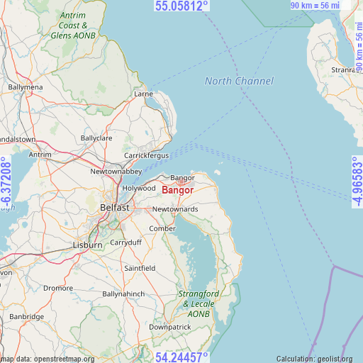
Bangor GPS coordinates[2]
54° 39' 12.168" North, 5° 40' 8.22" West
| Map corner | latitude | longitude |
|---|---|---|
| Upper-left | 55.05812°, | -6.37208° |
| Center: | 54.65338°, | -5.66895° |
| Lower-right: | 54.24457°, | -4.96583° |
| Map W x H: | 90.5×90.5 km | = 56.2×56.2mi |
| max Lat: | 60.39635° ⇑16.3% North |
| Bangor: | 54.65338° |
| min Lat: | ⇓83.7% South 34.60088° |
| min Long | Bangor | max Long |
| -7.64133° | -5.66895° | 32.95536° |
| W 2.2%⇐ | ⇒97.8% E |
Elevation
Elevation of Bangor is 45 m = 148 ft, and this is 27.9 m = 92 ft below average elevation for this country.
| Max E: |
515 m = 1690 ft | 61% |
| Avg. | 72.9 m = 239 ft | |
| Bangor | 45 m = 148 ft | |
Min E: |
-30 m = -98 ft | 39% |
See also: Bangor elevation on elevation.city.
Geographical zone
Bangor is located in North temperate zone (between Tropic of Cancer and the Arctic Circle). Distance of this North polar circle is 1324.3 km =822.9 mi to North.| Distance of | km | miles | from Bangor |
|---|---|---|---|
| North Pole | 3930.2 | 2442.1 | to North |
| Arctic Circle | 1324.3 | 822.9 | to North |
| Tropic Cancer | 3471 | 2156.8 | to South |
| Equator | 6076.9 | 3776 | to South |


Nearby cities:
15 places around Bangor: (largest is in red/bold)
• Ballywalter
17 km =10.6 mi,  135°
135°
• Belfast
17.7 km =11 mi,  249°
249°
• Carrickfergus
11.2 km =7 mi,  308°
308°
• Castlereagh
16.5 km =10.3 mi,  237°
237°
• Comber
12.5 km =7.8 mi,  202°
202°
• Donaghadee
8.7 km =5.4 mi,  98°
98°
• Dundonald
10.8 km =6.7 mi,  230°
230°
• Greenisland
14.2 km =8.8 mi,  291°
291°
• Greyabbey
14.9 km =9.3 mi,  152°
152°
• Holywood
10.2 km =6.3 mi,  260°
260°
• Jordanstown
15.2 km =9.4 mi,  282°
282°
• Millisle
10.4 km =6.5 mi,  120°
120°
• Newtownabbey
15.4 km =9.6 mi,  272°
272°
• Newtownards
6.9 km =4.3 mi,  191°
191°
• Whitehead
11.5 km =7.1 mi,  346°
346°
Sources, notices
• [Note1] Compared only with cities in United Kingdom existing in our database
• [Src1] Map data: © OpenStreetMap contributors (CC-BY-SA)
• [Src2] Other city data from geonames.org with taken over terms of usage.
• [Src3] Geographical zone / Annual Mean Temperature by Robert A. Rohde @ Wikipedia
