Castlereagh geodata
Castlereagh (Northern Ireland) is a seat of a second-order administrative division; located in United Kingdom in Europe/London (GMT+1) time zone. With population of 56,679 people, there are 202 cities with bigger population in this country. Compared to other cities in United Kingdom, 82.8% of cities are located further ↓South; 98.2% of cities are located further →East and 73.1% of cities have higher elevation than Castlereagh. Note1


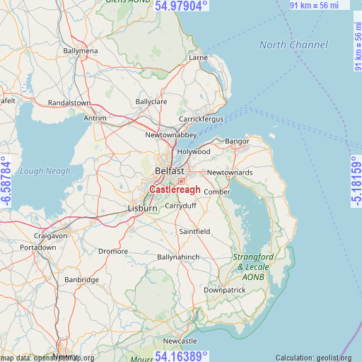
Castlereagh GPS coordinates[2]
54° 34' 24.6" North, 5° 53' 4.992" West
| Map corner | latitude | longitude |
|---|---|---|
| Upper-left | 54.97904°, | -6.58784° |
| Center: | 54.5735°, | -5.88472° |
| Lower-right: | 54.16389°, | -5.18159° |
| Map W x H: | 90.6×90.6 km | = 56.3×56.3mi |
| max Lat: | 60.39635° ⇑17.2% North |
| Castlereagh: | 54.5735° |
| min Lat: | ⇓82.8% South 34.60088° |
| min Long | Castlereagh | max Long |
| -7.64133° | -5.88472° | 32.95536° |
| W 1.8%⇐ | ⇒98.2% E |
Elevation
Elevation of Castlereagh is 29 m = 95 ft, and this is 43.9 m = 144 ft below average elevation for this country.
| Max E: |
515 m = 1690 ft | 73.1% |
| Avg. | 72.9 m = 239 ft | |
| Castlereagh | 29 m = 95 ft | |
Min E: |
-30 m = -98 ft | 26.9% |
See also: Castlereagh elevation on elevation.city.
Geographical zone
Castlereagh is located in North temperate zone (between Tropic of Cancer and the Arctic Circle). Distance of this North polar circle is 1333.2 km =828.4 mi to North.| Distance of | km | miles | from Castlereagh |
|---|---|---|---|
| North Pole | 3939.1 | 2447.6 | to North |
| Arctic Circle | 1333.2 | 828.4 | to North |
| Tropic Cancer | 3462.1 | 2151.2 | to South |
| Equator | 6068 | 3770.5 | to South |


Nearby cities:
15 places around Castlereagh: (largest is in red/bold)
• Ballygowan
10 km =6.2 mi,  143°
143°
• Bangor
16.5 km =10.3 mi,  57°
57°
• Belfast
3.7 km =2.3 mi,  314°
314°
• Carnmoney
12.9 km =8 mi,  341°
341°
• Carrickfergus
16.6 km =10.3 mi,  17°
17°
• Carryduff
6.2 km =3.9 mi,  181°
181°
• Comber
9.5 km =5.9 mi,  106°
106°
• Dundonald
6 km =3.7 mi,  69°
69°
• Greenisland
14.2 km =8.8 mi,  2°
2°
• Holywood
8.2 km =5.1 mi,  28°
28°
• Jordanstown
12.3 km =7.6 mi,  355°
355°
• Lisburn
11.2 km =7 mi,  240°
240°
• Newtownabbey
9.7 km =6 mi,  350°
350°
• Newtownards
12.7 km =7.9 mi,  80°
80°
• Saintfield
13 km =8.1 mi,  164°
164°
Sources, notices
• [Note1] Compared only with cities in United Kingdom existing in our database
• [Src1] Map data: © OpenStreetMap contributors (CC-BY-SA)
• [Src2] Other city data from geonames.org with taken over terms of usage.
• [Src3] Geographical zone / Annual Mean Temperature by Robert A. Rohde @ Wikipedia
