Banbury geodata
Banbury (England) is a populated place; located in United Kingdom in Europe/London (GMT+1) time zone. With population of 48,651 people, there are 241 cities with bigger population in this country. Compared to other cities in United Kingdom, 60.3% of cities are located further ↑North; 59.2% of cities are located further ←West and 72.2% of cities have lower elevation than Banbury. Note1
Administrative division(s):
- Level 1: England
- Level 2: Oxfordshire
- Level 3: Cherwell District
- Level 4: Banbury


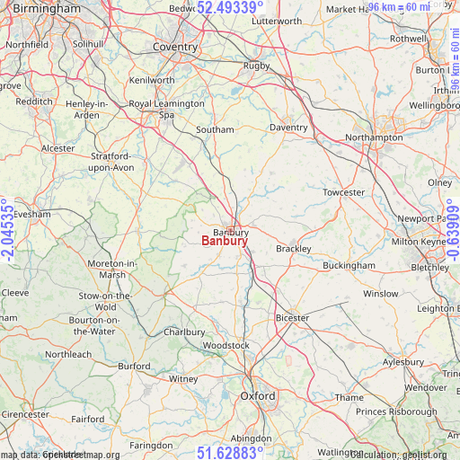
Banbury GPS coordinates[2]
52° 3' 47.52" North, 1° 20' 31.992" West
| Map corner | latitude | longitude |
|---|---|---|
| Upper-left | 52.49339°, | -2.04535° |
| Center: | 52.0632°, | -1.34222° |
| Lower-right: | 51.62883°, | -0.63909° |
| Map W x H: | 96.1×96.1 km | = 59.7×59.7mi |
| max Lat: | 60.39635° ⇑60.3% North |
| Banbury: | 52.0632° |
| min Lat: | ⇓39.7% South 34.60088° |
| min Long | Banbury | max Long |
| -7.64133° | -1.34222° | 32.95536° |
| W 59.2%⇐ | ⇒40.8% E |
Elevation
Elevation of Banbury is 100 m = 328 ft, and this is 27.1 m = 89 ft above average elevation for this country.
| Max E: |
515 m = 1690 ft | 27.8% |
| Banbury | 100 m 328 ft | |
| Avg. | 72.9 m = 239 ft | |
Min E: |
-30 m = -98 ft | 72.2% |
See also: Banbury elevation on elevation.city.
Geographical zone
Banbury is located in North temperate zone (between Tropic of Cancer and the Arctic Circle). Distance of this North polar circle is 1612.3 km =1001.8 mi to North.| Distance of | km | miles | from Banbury |
|---|---|---|---|
| North Pole | 4218.2 | 2621.1 | to North |
| Arctic Circle | 1612.3 | 1001.8 | to North |
| Tropic Cancer | 3183 | 1977.8 | to South |
| Equator | 5788.9 | 3597.1 | to South |


Nearby cities:
15 places around Banbury: (largest is in red/bold)
• Adderbury
5.5 km =3.4 mi,  158°
158°
• Aynho
9.8 km =6.1 mi,  141°
141°
• Barford St Michael
8.2 km =5.1 mi,  190°
190°
• Bloxham
5.2 km =3.2 mi,  204°
204°
• Chacombe
5.1 km =3.2 mi,  53°
53°
• Chipping Warden
9.3 km =5.8 mi,  30°
30°
• Claydon
9.5 km =5.9 mi,  3°
3°
• Cropredy
6.3 km =3.9 mi,  15°
15°
• Deddington
9.3 km =5.8 mi,  170°
170°
• Farnborough
9.1 km =5.7 mi,  348°
348°
• Greatworth
10.1 km =6.3 mi,  81°
81°
• Hanwell
3.6 km =2.2 mi,  330°
330°
• Kings Sutton
6.3 km =3.9 mi,  134°
134°
• Tadmarton
6.6 km =4.1 mi,  245°
245°
• Wardington
6.9 km =4.3 mi, 34°
Sources, notices
• [Note1] Compared only with cities in United Kingdom existing in our database
• [Src1] Map data: © OpenStreetMap contributors (CC-BY-SA)
• [Src2] Other city data from geonames.org with taken over terms of usage.
• [Src3] Geographical zone / Annual Mean Temperature by Robert A. Rohde @ Wikipedia
