Altrincham geodata
Altrincham (England) is a populated place; located in United Kingdom in Europe/London (GMT+1) time zone. With population of 41,548 people, there are 289 cities with bigger population in this country. Compared to other cities in United Kingdom, 67.6% of cities are located further ↓South; 62.2% of cities are located further →East and 63.1% of cities have higher elevation than Altrincham. Note1


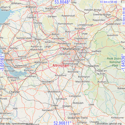
Altrincham GPS coordinates[2]
53° 23' 15.072" North, 2° 20' 54.528" West
| Map corner | latitude | longitude |
|---|---|---|
| Upper-left | 53.8048°, | -3.05161° |
| Center: | 53.38752°, | -2.34848° |
| Lower-right: | 52.96611°, | -1.64536° |
| Map W x H: | 93.3×93.3 km | = 58×58mi |
| max Lat: | 60.39635° ⇑32.4% North |
| Altrincham: | 53.38752° |
| min Lat: | ⇓67.6% South 34.60088° |
| min Long | Altrincham | max Long |
| -7.64133° | -2.34848° | 32.95536° |
| W 37.8%⇐ | ⇒62.2% E |
Elevation
Elevation of Altrincham is 42 m = 138 ft, and this is 30.9 m = 101 ft below average elevation for this country.
| Max E: |
515 m = 1690 ft | 63.1% |
| Avg. | 72.9 m = 239 ft | |
| Altrincham | 42 m = 138 ft | |
Min E: |
-30 m = -98 ft | 36.9% |
See also: Altrincham elevation on elevation.city.
Geographical zone
Altrincham is located in North temperate zone (between Tropic of Cancer and the Arctic Circle). Distance of this North polar circle is 1465 km =910.3 mi to North.| Distance of | km | miles | from Altrincham |
|---|---|---|---|
| North Pole | 4070.9 | 2529.5 | to North |
| Arctic Circle | 1465 | 910.3 | to North |
| Tropic Cancer | 3330.2 | 2069.3 | to South |
| Equator | 5936.1 | 3688.5 | to South |


Nearby cities:
15 places around Altrincham: (largest is in red/bold)
• Ashley
4.3 km =2.7 mi,  166°
166°
• Bowdon
1.7 km =1.1 mi,  222°
222°
• Carrington
5.6 km =3.5 mi,  335°
335°
• Chorlton cum Hardy
7.7 km =4.8 mi,  46°
46°
• Hale
1.5 km =0.9 mi,  134°
134°
• High Legh
8.1 km =5 mi,  240°
240°
• Irlam
7.9 km =4.9 mi,  320°
320°
• Mere
7.4 km =4.6 mi,  213°
213°
• Mobberley
8.2 km =5.1 mi,  164°
164°
• Partington
6.3 km =3.9 mi,  303°
303°
• Ringway
6 km =3.7 mi, 133°
• Sale
4.5 km =2.8 mi,  20°
20°
• Stretford
7.3 km =4.5 mi, 16°
• Timperley
1.7 km =1.1 mi,  35°
35°
• Urmston
6.8 km =4.2 mi,  356°
356°
Sources, notices
• [Note1] Compared only with cities in United Kingdom existing in our database
• [Src1] Map data: © OpenStreetMap contributors (CC-BY-SA)
• [Src2] Other city data from geonames.org with taken over terms of usage.
• [Src3] Geographical zone / Annual Mean Temperature by Robert A. Rohde @ Wikipedia
