Urmston geodata
Urmston (England) is a populated place; located in United Kingdom in Europe/London (GMT+1) time zone. With population of 41,198 people, there are 296 cities with bigger population in this country. Compared to other cities in United Kingdom, 68.8% of cities are located further ↓South; 62.4% of cities are located further →East and 75.4% of cities have higher elevation than Urmston. Note1


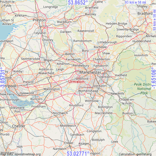
Urmston GPS coordinates[2]
53° 26' 54.672" North, 2° 21' 15.084" West
| Map corner | latitude | longitude |
|---|---|---|
| Upper-left | 53.8652°, | -3.05731° |
| Center: | 53.44852°, | -2.35419° |
| Lower-right: | 53.02771°, | -1.65106° |
| Map W x H: | 93.1×93.1 km | = 57.8×57.8mi |
| max Lat: | 60.39635° ⇑31.2% North |
| Urmston: | 53.44852° |
| min Lat: | ⇓68.8% South 34.60088° |
| min Long | Urmston | max Long |
| -7.64133° | -2.35419° | 32.95536° |
| W 37.6%⇐ | ⇒62.4% E |
Elevation
Elevation of Urmston is 26 m = 85 ft, and this is 46.9 m = 154 ft below average elevation for this country.
| Max E: |
515 m = 1690 ft | 75.4% |
| Avg. | 72.9 m = 239 ft | |
| Urmston | 26 m = 85 ft | |
Min E: |
-30 m = -98 ft | 24.6% |
See also: Urmston elevation on elevation.city.
Geographical zone
Urmston is located in North temperate zone (between Tropic of Cancer and the Arctic Circle). Distance of this North polar circle is 1458.3 km =906.1 mi to North.| Distance of | km | miles | from Urmston |
|---|---|---|---|
| North Pole | 4064.1 | 2525.3 | to North |
| Arctic Circle | 1458.3 | 906.1 | to North |
| Tropic Cancer | 3337 | 2073.5 | to South |
| Equator | 5942.9 | 3692.7 | to South |


Nearby cities:
15 places around Urmston: (largest is in red/bold)
• Altrincham
6.8 km =4.2 mi,  176°
176°
• Bowdon
8 km =5 mi,  185°
185°
• Carrington
2.6 km =1.6 mi,  228°
228°
• Chorlton cum Hardy
6.2 km =3.9 mi,  103°
103°
• Eccles
4.1 km =2.5 mi,  19°
19°
• Hale
7.9 km =4.9 mi,  169°
169°
• Hulme
7.2 km =4.5 mi,  74°
74°
• Irlam
4.6 km =2.9 mi,  261°
261°
• Partington
5.9 km =3.7 mi,  236°
236°
• Sale
3.3 km =2.1 mi,  142°
142°
• Salford
6.1 km =3.8 mi,  44°
44°
• Stretford
2.5 km =1.6 mi,  86°
86°
• Swinton
5.7 km =3.5 mi,  2°
2°
• Timperley
5.6 km =3.5 mi, 165°
• Trafford Park
3.6 km =2.2 mi,  51°
51°
Sources, notices
• [Note1] Compared only with cities in United Kingdom existing in our database
• [Src1] Map data: © OpenStreetMap contributors (CC-BY-SA)
• [Src2] Other city data from geonames.org with taken over terms of usage.
• [Src3] Geographical zone / Annual Mean Temperature by Robert A. Rohde @ Wikipedia
