Pont Rhyd-y-cyff geodata
Pont Rhyd-y-cyff (Wales) is a populated place; located in United Kingdom in Europe/London (GMT+1) time zone. With population of 1,505 people, there are 3040 cities with bigger population in this country. Compared to other cities in United Kingdom, 74.8% of cities are located further ↑North; 84.1% of cities are located further →East and 86.3% of cities have lower elevation than Pont Rhyd-y-cyff. Note1
Administrative division(s):
- Level 1: Wales
- Level 2: Bridgend county borough
- Level 3: Llangynwyd Middle


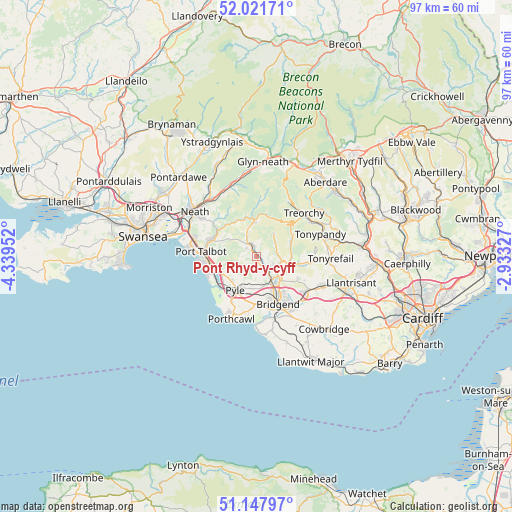
Pont Rhyd-y-cyff GPS coordinates[2]
51° 35' 12.984" North, 3° 38' 11.004" West
| Map corner | latitude | longitude |
|---|---|---|
| Upper-left | 52.02171°, | -4.33952° |
| Center: | 51.58694°, | -3.63639° |
| Lower-right: | 51.14797°, | -2.93327° |
| Map W x H: | 97.2×97.1 km | = 60.4×60.3mi |
| max Lat: | 60.39635° ⇑74.8% North |
| Pont Rhyd-y-cyff: | 51.58694° |
| min Lat: | ⇓25.2% South 34.60088° |
| min Long | Pont Rhyd-y-cyf | max Long |
| -7.64133° | -3.63639° | 32.95536° |
| W 15.9%⇐ | ⇒84.1% E |
Elevation
Elevation of Pont Rhyd-y-cyff is 136 m = 446 ft, and this is 63.1 m = 207 ft above average elevation for this country.
| Max E: |
515 m = 1690 ft | 13.7% |
| Pont Rhyd-y-cyff | 136 m 446 ft | |
| Avg. | 72.9 m = 239 ft | |
Min E: |
-30 m = -98 ft | 86.3% |
See also: United Kingdom elevation on elevation.city.
Geographical zone
Pont Rhyd-y-cyff is located in North temperate zone (between Tropic of Cancer and the Arctic Circle). Distance of this North polar circle is 1665.2 km =1034.7 mi to North.| Distance of | km | miles | from Pont Rhyd-y-cyff |
|---|---|---|---|
| North Pole | 4271.1 | 2653.9 | to North |
| Arctic Circle | 1665.2 | 1034.7 | to North |
| Tropic Cancer | 3130 | 1944.9 | to South |
| Equator | 5735.9 | 3564.1 | to South |


Nearby cities:
15 places around Pont Rhyd-y-cyff: (largest is in red/bold)
• Aberkenfig
5.9 km =3.7 mi,  151°
151°
• Betws
3.9 km =2.4 mi,  120°
120°
• Blackmill
7 km =4.3 mi,  107°
107°
• Blaengwynfi
8 km =5 mi,  16°
16°
• Bryn
6.1 km =3.8 mi,  302°
302°
• Cefn Cribwr
6.2 km =3.9 mi,  190°
190°
• Croeserw
6.4 km =4 mi,  357°
357°
• Heol-y-Cyw
9 km =5.6 mi, 119°
• Llangeinor
4.8 km =3 mi, 105°
• Maesteg
2.9 km =1.8 mi,  328°
328°
• Ogmore Vale
6.7 km =4.2 mi,  75°
75°
• Pontycymer
4.5 km =2.8 mi,  53°
53°
• Price Town
7.7 km =4.8 mi,  63°
63°
• Pyle
9 km =5.6 mi,  209°
209°
• Taibach
9 km =5.6 mi,  267°
267°
Sources, notices
• [Note1] Compared only with cities in United Kingdom existing in our database
• [Src1] Map data: © OpenStreetMap contributors (CC-BY-SA)
• [Src2] Other city data from geonames.org with taken over terms of usage.
• [Src3] Geographical zone / Annual Mean Temperature by Robert A. Rohde @ Wikipedia
