Camber geodata
Camber (England) is a populated place; located in United Kingdom in Europe/London (GMT+1) time zone. With population of 1,265 people, there are 3284 cities with bigger population in this country. Compared to other cities in United Kingdom, 92.5% of cities are located further ↑North; 95% of cities are located further ←West and 99% of cities have higher elevation than Camber. Note1
Administrative division(s):
- Level 1: England
- Level 2: East Sussex
- Level 3: Rother District
- Level 4: Camber


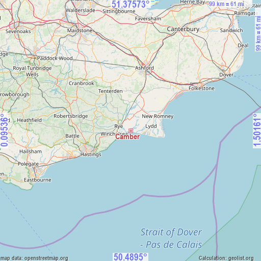
Camber GPS coordinates[2]
50° 56' 5.028" North, 0° 47' 54.528" East
| Map corner | latitude | longitude |
|---|---|---|
| Upper-left | 51.37573°, | 0.09536° |
| Center: | 50.93473°, | 0.79848° |
| Lower-right: | 50.4895°, | 1.50161° |
| Map W x H: | 98.5×98.5 km | = 61.2×61.2mi |
| max Lat: | 60.39635° ⇑92.5% North |
| Camber: | 50.93473° |
| min Lat: | ⇓7.5% South 34.60088° |
| min Long | Camber | max Long |
| -7.64133° | 0.79848° | 32.95536° |
| W 95%⇐ | ⇒5% E |
Elevation
Elevation of Camber is 4 m = 13 ft, and this is 68.9 m = 226 ft below average elevation for this country.
| Max E: |
515 m = 1690 ft | 99% |
| Avg. | 72.9 m = 239 ft | |
| Camber | 4 m = 13 ft | |
Min E: |
-30 m = -98 ft | 1% |
See also: United Kingdom elevation on elevation.city.
Geographical zone
Camber is located in North temperate zone (between Tropic of Cancer and the Arctic Circle). Distance of this North polar circle is 1737.8 km =1079.8 mi to North.| Distance of | km | miles | from Camber |
|---|---|---|---|
| North Pole | 4343.7 | 2699 | to North |
| Arctic Circle | 1737.8 | 1079.8 | to North |
| Tropic Cancer | 3057.5 | 1899.8 | to South |
| Equator | 5663.4 | 3519.1 | to South |


Nearby cities:
15 places around Camber: (largest is in red/bold)
• Dymchurch
17 km =10.6 mi,  53°
53°
• Fairlight
11.8 km =7.3 mi,  237°
237°
• Icklesham
9.4 km =5.8 mi,  257°
257°
• Ivychurch
10.7 km =6.6 mi,  36°
36°
• Lydd
7.8 km =4.8 mi,  76°
76°
• New Romney
11.5 km =7.1 mi,  60°
60°
• Northiam
15.4 km =9.6 mi,  295°
295°
• Romney Marsh
12.8 km =8 mi, 39°
• Rye
4.9 km =3 mi,  291°
291°
• St Mary's Bay
15.1 km =9.4 mi, 56°
• Stone
7.6 km =4.7 mi,  342°
342°
• Tenterden
16.8 km =10.4 mi,  332°
332°
• Winchelsea Beach
5.7 km =3.5 mi,  249°
249°
• Wittersham
10.9 km =6.8 mi,  324°
324°
• Woodchurch
15.8 km =9.8 mi,  353°
353°
Sources, notices
• [Note1] Compared only with cities in United Kingdom existing in our database
• [Src1] Map data: © OpenStreetMap contributors (CC-BY-SA)
• [Src2] Other city data from geonames.org with taken over terms of usage.
• [Src3] Geographical zone / Annual Mean Temperature by Robert A. Rohde @ Wikipedia
