Bethesda geodata
Bethesda (Wales) is a seat of a third-order administrative division; located in United Kingdom in Europe/London (GMT+0) time zone. With population of 4,735 people, there are 1686 cities with bigger population in this country. Compared to other cities in United Kingdom, 63.5% of cities are located further ↓South; 88.7% of cities are located further →East and 94.2% of cities have lower elevation than Bethesda. Note1


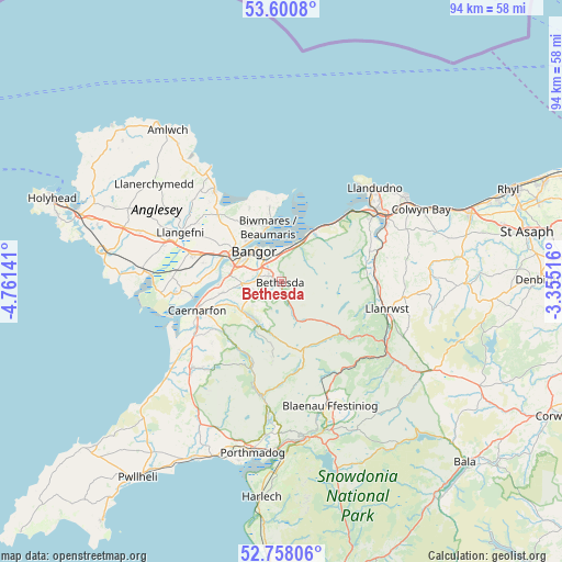
Bethesda GPS coordinates[2]
53° 10' 53.4" North, 4° 3' 29.808" West
| Map corner | latitude | longitude |
|---|---|---|
| Upper-left | 53.6008°, | -4.76141° |
| Center: | 53.1815°, | -4.05828° |
| Lower-right: | 52.75806°, | -3.35516° |
| Map W x H: | 93.7×93.7 km | = 58.2×58.2mi |
| max Lat: | 60.39635° ⇑36.5% North |
| Bethesda: | 53.1815° |
| min Lat: | ⇓63.5% South 34.60088° |
| min Long | Bethesda | max Long |
| -7.64133° | -4.05828° | 32.95536° |
| W 11.3%⇐ | ⇒88.7% E |
Elevation
Elevation of Bethesda is 176 m = 577 ft, and this is 103.1 m = 338 ft above average elevation for this country.
| Max E: |
515 m = 1690 ft | 5.8% |
| Bethesda | 176 m 577 ft | |
| Avg. | 72.9 m = 239 ft | |
Min E: |
-30 m = -98 ft | 94.2% |
See also: United Kingdom elevation on elevation.city.
Geographical zone
Bethesda is located in North temperate zone (between Tropic of Cancer and the Arctic Circle). Distance of this North polar circle is 1487.9 km =924.5 mi to North.| Distance of | km | miles | from Bethesda |
|---|---|---|---|
| North Pole | 4093.8 | 2543.8 | to North |
| Arctic Circle | 1487.9 | 924.5 | to North |
| Tropic Cancer | 3307.3 | 2055.1 | to South |
| Equator | 5913.2 | 3674.3 | to South |


Nearby cities:
15 places around Bethesda: (largest is in red/bold)
• Aber
6.4 km =4 mi,  25°
25°
• Bangor
7 km =4.3 mi,  317°
317°
• Beaumaris
9.4 km =5.8 mi,  345°
345°
• Caernarfon
14.8 km =9.2 mi,  252°
252°
• Deiniolen
6.1 km =3.8 mi,  232°
232°
• Llanberis
8.5 km =5.3 mi,  213°
213°
• Llanddona
13.4 km =8.3 mi,  337°
337°
• Llanfairfechan
10.2 km =6.3 mi, 33°
• Llanfairpwllgwyngyll
10.6 km =6.6 mi,  294°
294°
• Llangoed
12.7 km =7.9 mi, 351°
• Llanrug
9.9 km =6.2 mi, 247°
• Menai Bridge
9 km =5.6 mi,  304°
304°
• Penmaenmawr
12.6 km =7.8 mi,  41°
41°
• Tregarth
2.2 km =1.4 mi, 295°
• Y Felinheli
9.8 km =6.1 mi,  273°
273°
Sources, notices
• [Note1] Compared only with cities in United Kingdom existing in our database
• [Src1] Map data: © OpenStreetMap contributors (CC-BY-SA)
• [Src2] Other city data from geonames.org with taken over terms of usage.
• [Src3] Geographical zone / Annual Mean Temperature by Robert A. Rohde @ Wikipedia
