Stoke-sub-Hamdon geodata
Stoke-sub-Hamdon (England) is a populated place; located in United Kingdom in Europe/London (GMT+1) time zone. With population of 2,004 people, there are 2623 cities with bigger population in this country. Compared to other cities in United Kingdom, 92.2% of cities are located further ↑North; 69.7% of cities are located further →East and 55.1% of cities have higher elevation than Stoke-sub-Hamdon. Note1
Administrative division(s):
- Level 1: England
- Level 2: Somerset
- Level 3: South Somerset District
- Level 4: Stoke Sub Hamdon


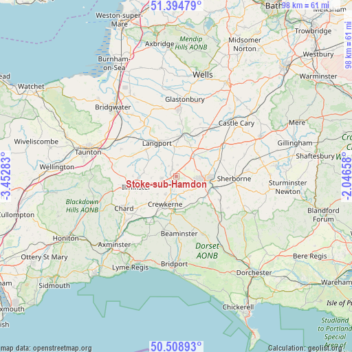
Stoke-sub-Hamdon GPS coordinates[2]
50° 57' 14.292" North, 2° 44' 58.956" West
| Map corner | latitude | longitude |
|---|---|---|
| Upper-left | 51.39479°, | -3.45283° |
| Center: | 50.95397°, | -2.74971° |
| Lower-right: | 50.50893°, | -2.04658° |
| Map W x H: | 98.5×98.5 km | = 61.2×61.2mi |
| max Lat: | 60.39635° ⇑92.2% North |
| Stoke-sub-Hamdon: | 50.95397° |
| min Lat: | ⇓7.8% South 34.60088° |
| min Long | Stoke-sub-Hamdo | max Long |
| -7.64133° | -2.74971° | 32.95536° |
| W 30.3%⇐ | ⇒69.7% E |
Elevation
Elevation of Stoke-sub-Hamdon is 53 m = 174 ft, and this is 19.9 m = 65 ft below average elevation for this country.
| Max E: |
515 m = 1690 ft | 55.1% |
| Avg. | 72.9 m = 239 ft | |
| Stoke-sub-Hamdon | 53 m = 174 ft | |
Min E: |
-30 m = -98 ft | 44.9% |
See also: United Kingdom elevation on elevation.city.
Geographical zone
Stoke-sub-Hamdon is located in North temperate zone (between Tropic of Cancer and the Arctic Circle). Distance of this North polar circle is 1735.6 km =1078.5 mi to North.| Distance of | km | miles | from Stoke-sub-Hamdon |
|---|---|---|---|
| North Pole | 4341.5 | 2697.7 | to North |
| Arctic Circle | 1735.6 | 1078.5 | to North |
| Tropic Cancer | 3059.6 | 1901.1 | to South |
| Equator | 5665.6 | 3520.4 | to South |


Nearby cities:
15 places around Stoke-sub-Hamdon: (largest is in red/bold)
• Chilthorne Domer
5.3 km =3.3 mi,  69°
69°
• Crewkerne
8.5 km =5.3 mi,  202°
202°
• Haselbury Plucknett
6.6 km =4.1 mi,  181°
181°
• Ilchester
7.6 km =4.7 mi,  40°
40°
• Kingsbury Episcopi
5.5 km =3.4 mi,  313°
313°
• Langport
10.8 km =6.7 mi,  329°
329°
• Martock
2.5 km =1.6 mi, 331°
• Merriott
5.6 km =3.5 mi,  214°
214°
• Montacute
2.4 km =1.5 mi,  100°
100°
• Odcombe
4 km =2.5 mi,  123°
123°
• South Petherton
4.1 km =2.5 mi,  261°
261°
• Tintinhull
3.3 km =2.1 mi,  49°
49°
• West Chinnock
4 km =2.5 mi,  189°
189°
• West Coker
5.9 km =3.7 mi,  131°
131°
• Yeovil
8.4 km =5.2 mi, 99°
Sources, notices
• [Note1] Compared only with cities in United Kingdom existing in our database
• [Src1] Map data: © OpenStreetMap contributors (CC-BY-SA)
• [Src2] Other city data from geonames.org with taken over terms of usage.
• [Src3] Geographical zone / Annual Mean Temperature by Robert A. Rohde @ Wikipedia
