Dunbeg geodata
Dunbeg (Scotland) is a populated place; located in United Kingdom in Europe/London (GMT+1) time zone. With population of 610 people, there are 4543 cities with bigger population in this country. Compared to other cities in United Kingdom, 96.5% of cities are located further ↓South; 97.5% of cities are located further →East and 89.9% of cities have higher elevation than Dunbeg. Note1


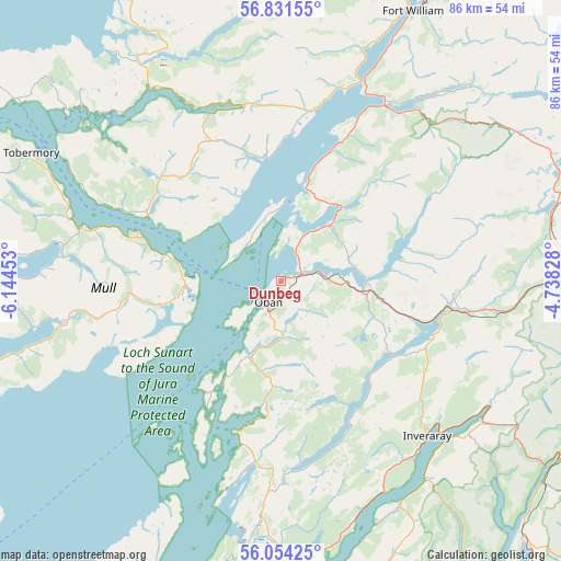
Dunbeg GPS coordinates[2]
56° 26' 41.604" North, 5° 26' 29.076" West
| Map corner | latitude | longitude |
|---|---|---|
| Upper-left | 56.83155°, | -6.14453° |
| Center: | 56.44489°, | -5.44141° |
| Lower-right: | 56.05425°, | -4.73828° |
| Map W x H: | 86.4×86.4 km | = 53.7×53.7mi |
| max Lat: | 60.39635° ⇑3.5% North |
| Dunbeg: | 56.44489° |
| min Lat: | ⇓96.5% South 34.60088° |
| min Long | Dunbeg | max Long |
| -7.64133° | -5.44141° | 32.95536° |
| W 2.5%⇐ | ⇒97.5% E |
Elevation
Elevation of Dunbeg is 12 m = 39 ft, and this is 60.9 m = 200 ft below average elevation for this country.
| Max E: |
515 m = 1690 ft | 89.9% |
| Avg. | 72.9 m = 239 ft | |
| Dunbeg | 12 m = 39 ft | |
Min E: |
-30 m = -98 ft | 10.1% |
See also: United Kingdom elevation on elevation.city.
Geographical zone
Dunbeg is located in North temperate zone (between Tropic of Cancer and the Arctic Circle). Distance of this North polar circle is 1125.1 km =699.1 mi to North.| Distance of | km | miles | from Dunbeg |
|---|---|---|---|
| North Pole | 3731 | 2318.3 | to North |
| Arctic Circle | 1125.1 | 699.1 | to North |
| Tropic Cancer | 3670.2 | 2280.6 | to South |
| Equator | 6276.1 | 3899.8 | to South |


Nearby cities:
15 places around Dunbeg: (largest is in red/bold)
• Ardrishaig
47.7 km =29.6 mi,  180°
180°
• Ballachulish
31.7 km =19.7 mi,  35°
35°
• Caol
48.3 km =30 mi,  25°
25°
• Fort William
46 km =28.6 mi, 25°
• Garelochhead
55.3 km =34.4 mi,  136°
136°
• Inveraray
32.8 km =20.4 mi, 136°
• Isle Of Mull
20.4 km =12.7 mi,  270°
270°
• Kinlochleven
41.2 km =25.6 mi, 44°
• Lochgilphead
45.3 km =28.1 mi, 179°
• Oban
3.8 km =2.4 mi,  209°
209°
• Sandbank
59.8 km =37.2 mi,  149°
149°
• Spean Bridge
59 km =36.7 mi, 32°
• Strone
60.8 km =37.8 mi, 147°
• Tighnabruaich
61.3 km =38.1 mi,  167°
167°
• Tobermory
43.4 km =27 mi,  296°
296°
Sources, notices
• [Note1] Compared only with cities in United Kingdom existing in our database
• [Src1] Map data: © OpenStreetMap contributors (CC-BY-SA)
• [Src2] Other city data from geonames.org with taken over terms of usage.
• [Src3] Geographical zone / Annual Mean Temperature by Robert A. Rohde @ Wikipedia
