Maxwellheugh geodata
Maxwellheugh (Scotland) is a section of populated place; located in United Kingdom in Europe/London (GMT+1) time zone. With population of 1,160 people, there are 3412 cities with bigger population in this country. Compared to other cities in United Kingdom, 89.2% of cities are located further ↓South; 63.7% of cities are located further →East and 50.3% of cities have lower elevation than Maxwellheugh. Note1


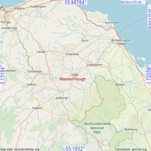
Maxwellheugh GPS coordinates[2]
55° 35' 33.108" North, 2° 25' 43.356" West
| Map corner | latitude | longitude |
|---|---|---|
| Upper-left | 55.98784°, | -3.13184° |
| Center: | 55.59253°, | -2.42871° |
| Lower-right: | 55.1932°, | -1.72559° |
| Map W x H: | 88.4×88.4 km | = 54.9×54.9mi |
| max Lat: | 60.39635° ⇑10.8% North |
| Maxwellheugh: | 55.59253° |
| min Lat: | ⇓89.2% South 34.60088° |
| min Long | Maxwellheugh | max Long |
| -7.64133° | -2.42871° | 32.95536° |
| W 36.3%⇐ | ⇒63.7% E |
Elevation
Elevation of Maxwellheugh is 61 m = 200 ft, and this is 11.9 m = 39 ft below average elevation for this country.
| Max E: |
515 m = 1690 ft | 49.7% |
| Avg. | 72.9 m = 239 ft | |
| Maxwellheugh | 61 m = 200 ft | |
Min E: |
-30 m = -98 ft | 50.3% |
See also: United Kingdom elevation on elevation.city.
Geographical zone
Maxwellheugh is located in North temperate zone (between Tropic of Cancer and the Arctic Circle). Distance of this North polar circle is 1219.9 km =758 mi to North.| Distance of | km | miles | from Maxwellheugh |
|---|---|---|---|
| North Pole | 3825.8 | 2377.2 | to North |
| Arctic Circle | 1219.9 | 758 | to North |
| Tropic Cancer | 3575.4 | 2221.6 | to South |
| Equator | 6181.3 | 3840.9 | to South |


Nearby cities:
15 places around Maxwellheugh: (largest is in red/bold)
• Coldstream
12.8 km =8 mi,  59°
59°
• Denholm
22.1 km =13.7 mi,  226°
226°
• Duns
21.2 km =13.2 mi,  14°
14°
• Earlston
16.3 km =10.1 mi,  288°
288°
• Ford
22.2 km =13.8 mi,  78°
78°
• Greenlaw
12.9 km =8 mi,  350°
350°
• Jedburgh
14.7 km =9.1 mi,  211°
211°
• Kelso
0.7 km =0.4 mi,  332°
332°
• Kirknewton
19.2 km =11.9 mi,  104°
104°
• Melrose
18.8 km =11.7 mi,  272°
272°
• Newtown St Boswells
15.2 km =9.4 mi,  264°
264°
• Norham
21.8 km =13.5 mi,  49°
49°
• Saint Boswells
13.7 km =8.5 mi, 260°
• Town Yetholm
10.3 km =6.4 mi,  120°
120°
• Tweedbank
21.3 km =13.2 mi, 273°
Sources, notices
• [Note1] Compared only with cities in United Kingdom existing in our database
• [Src1] Map data: © OpenStreetMap contributors (CC-BY-SA)
• [Src2] Other city data from geonames.org with taken over terms of usage.
• [Src3] Geographical zone / Annual Mean Temperature by Robert A. Rohde @ Wikipedia
