Jakaba geodata
Jakaba (Central River) is a populated place; located in Gambia in Africa/Banjul (GMT+0) time zone. With population of 837 people, there are 77 cities with bigger population in this country. Compared to other cities in Gambia, 93.5% of cities are located further ↓South; 70.7% of cities are located further ←West and 64.2% of cities have higher elevation than Jakaba. Note1


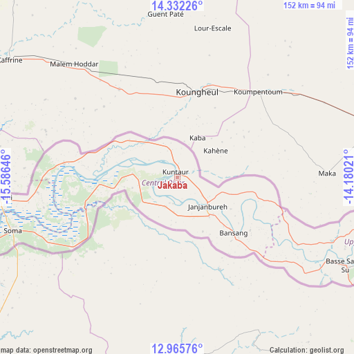
Jakaba GPS coordinates[2]
13° 39' 0" North, 14° 52' 59.988" West
| Map corner | latitude | longitude |
|---|---|---|
| Upper-left | 14.33226°, | -15.58646° |
| Center: | 13.65°, | -14.88333° |
| Lower-right: | 12.96576°, | -14.18021° |
| Map W x H: | 151.9×151.9 km | = 94.4×94.4mi |
| max Lat: | 13.8° ⇑6.5% North |
| Jakaba: | 13.65° |
| min Lat: | ⇓93.5% South 13.20194° |
| min Long | Jakaba | max Long |
| -16.73389° | -14.88333° | -13.85° |
| W 70.7%⇐ | ⇒29.3% E |
Elevation
Elevation of Jakaba is 16 m = 52 ft, and this is 5.1 m = 17 ft below average elevation for this country.
| Max E: |
49 m = 161 ft | 64.2% |
| Avg. | 21.1 m = 69 ft | |
| Jakaba | 16 m = 52 ft | |
Min E: |
1 m = 3 ft | 35.8% |
See also: Gambia elevation on elevation.city.
Geographical zone
Jakaba is located in North Torrid zone (between Equator and Tropic of Cancer). Distance of this Northern Tropic circle is 1088.2 km =676.2 mi to North.| Distance of | km | miles | from Jakaba |
|---|---|---|---|
| North Pole | 8489.3 | 5275 | to North |
| Arctic Circle | 5883.4 | 3655.8 | to North |
| Tropic Cancer | 1088.2 | 676.2 | to North |
| Equator | 1517.7 | 943.1 | to South |


Nearby cities:
15 places around Jakaba: (largest is in red/bold)
• Bani
19.7 km =12.2 mi,  124°
124°
• Brikama Nding
14.1 km =8.8 mi,  202°
202°
• Denton
17.5 km =10.9 mi, 197°
• Dingirie
13.5 km =8.4 mi,  344°
344°
• Georgetown
17.8 km =11.1 mi,  133°
133°
• Jakhaly
14.3 km =8.9 mi,  219°
219°
• Karantaba
16.3 km =10.1 mi,  276°
276°
• Kass Wollof
15.8 km =9.8 mi, 339°
• Kuntaur
2.4 km =1.5 mi, 343°
• Madina
5.6 km =3.5 mi,  0°
0°
• Mara Magai
15.3 km =9.5 mi,  193°
193°
• Saruja
11.7 km =7.3 mi, 197°
• Sukuta
5.2 km =3.2 mi, 224°
• Tuba Koto
2.6 km =1.6 mi, 224°
• Wassu
4.6 km =2.9 mi,  6°
6°
Sources, notices
• [Note1] Compared only with cities in Gambia existing in our database
• [Src1] Map data: © OpenStreetMap contributors (CC-BY-SA)
• [Src2] Other city data from geonames.org with taken over terms of usage.
• [Src3] Geographical zone / Annual Mean Temperature by Robert A. Rohde @ Wikipedia
