Georgetown geodata
Georgetown (Central River) is a seat of a first-order administrative division; located in Gambia in Africa/Banjul (GMT+0) time zone. With population of 3,584 people, there are 18 cities with bigger population in this country. Compared to other cities in Gambia, 76.4% of cities are located further ↓South; 74% of cities are located further ←West and 91.9% of cities have higher elevation than Georgetown. Note1


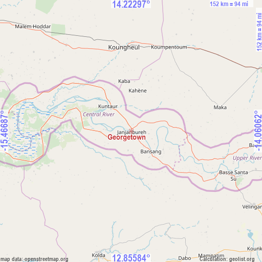
Georgetown GPS coordinates[2]
13° 32' 25.404" North, 14° 45' 49.464" West
| Map corner | latitude | longitude |
|---|---|---|
| Upper-left | 14.22297°, | -15.46687° |
| Center: | 13.54039°, | -14.76374° |
| Lower-right: | 12.85584°, | -14.06062° |
| Map W x H: | 152×152 km | = 94.4×94.4mi |
| max Lat: | 13.8° ⇑23.6% North |
| Georgetown: | 13.54039° |
| min Lat: | ⇓76.4% South 13.20194° |
| min Long | Georgetown | max Long |
| -16.73389° | -14.76374° | -13.85° |
| W 74%⇐ | ⇒26% E |
Elevation
Elevation of Georgetown is 7 m = 23 ft, and this is 14.1 m = 46 ft below average elevation for this country.
| Max E: |
49 m = 161 ft | 91.9% |
| Avg. | 21.1 m = 69 ft | |
| Georgetown | 7 m = 23 ft | |
Min E: |
1 m = 3 ft | 8.1% |
See also: Gambia elevation on elevation.city.
Geographical zone
Georgetown is located in North Torrid zone (between Equator and Tropic of Cancer). Distance of this Northern Tropic circle is 1100.4 km =683.8 mi to North.| Distance of | km | miles | from Georgetown |
|---|---|---|---|
| North Pole | 8501.5 | 5282.6 | to North |
| Arctic Circle | 5895.6 | 3663.4 | to North |
| Tropic Cancer | 1100.4 | 683.8 | to North |
| Equator | 1505.6 | 935.5 | to South |


Nearby cities:
15 places around Georgetown: (largest is in red/bold)
• Bani
3.5 km =2.2 mi,  71°
71°
• Bansang
17.1 km =10.6 mi,  134°
134°
• Brikama Nding
18.3 km =11.4 mi,  267°
267°
• Denton
18.9 km =11.7 mi,  256°
256°
• Dobbo
16.3 km =10.1 mi,  120°
120°
• Galleh Manda
12.1 km =7.5 mi,  190°
190°
• Jakaba
17.8 km =11.1 mi,  313°
313°
• Kunting
10.5 km =6.5 mi,  94°
94°
• Madina Tunjang
12 km =7.5 mi,  172°
172°
• Mara Magai
16.7 km =10.4 mi, 260°
• Saruja
16.6 km =10.3 mi, 273°
• Sukuta
18.6 km =11.6 mi,  297°
297°
• Sulolor
14.5 km =9 mi, 133°
• Tuba
11.9 km =7.4 mi, 133°
• Tuba Koto
18 km =11.2 mi, 305°
Sources, notices
• [Note1] Compared only with cities in Gambia existing in our database
• [Src1] Map data: © OpenStreetMap contributors (CC-BY-SA)
• [Src2] Other city data from geonames.org with taken over terms of usage.
• [Src3] Geographical zone / Annual Mean Temperature by Robert A. Rohde @ Wikipedia
