Fass geodata
Fass (Central River) is a populated place; located in Gambia in Africa/Banjul (GMT+0) time zone. With population of 826 people, there are 78 cities with bigger population in this country. Compared to other cities in Gambia, 100% of cities are located further ↓South; 60.2% of cities are located further ←West and 55.3% of cities have lower elevation than Fass. Note1


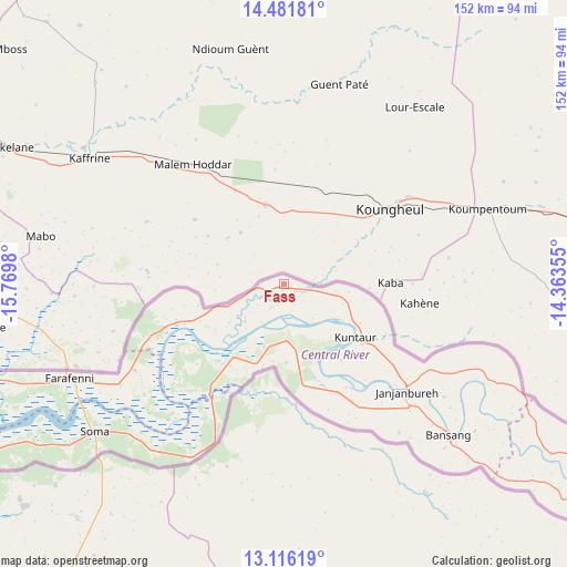
Fass GPS coordinates[2]
13° 48' 0" North, 15° 4' 0.012" West
| Map corner | latitude | longitude |
|---|---|---|
| Upper-left | 14.48181°, | -15.7698° |
| Center: | 13.8°, | -15.06667° |
| Lower-right: | 13.11619°, | -14.36355° |
| Map W x H: | 151.8×151.8 km | = 94.3×94.3mi |
| max Lat: | 13.8° ⇑0% North |
| Fass: | 13.8° |
| min Lat: | ⇓100% South 13.20194° |
| min Long | Fass | max Long |
| -16.73389° | -15.06667° | -13.85° |
| W 60.2%⇐ | ⇒39.8% E |
Elevation
Elevation of Fass is 21 m = 69 ft, and this is 0.1 m = 0 ft below average elevation for this country.
| Max E: |
49 m = 161 ft | 44.7% |
| Avg. | 21.1 m = 69 ft | |
| Fass | 21 m = 69 ft | |
Min E: |
1 m = 3 ft | 55.3% |
See also: Gambia elevation on elevation.city.
Geographical zone
Fass is located in North Torrid zone (between Equator and Tropic of Cancer). Distance of this Northern Tropic circle is 1071.5 km =665.8 mi to North.| Distance of | km | miles | from Fass |
|---|---|---|---|
| North Pole | 8472.6 | 5264.6 | to North |
| Arctic Circle | 5866.8 | 3645.5 | to North |
| Tropic Cancer | 1071.5 | 665.8 | to North |
| Equator | 1534.4 | 953.4 | to South |


Nearby cities:
15 places around Fass: (largest is in red/bold)
• Bati Ndar
18.2 km =11.3 mi,  232°
232°
• Dingirie
16.6 km =10.3 mi,  102°
102°
• Jakaba
25.9 km =16.1 mi,  130°
130°
• Jakhaly
29.8 km =18.5 mi,  158°
158°
• Jarreng
24 km =14.9 mi,  211°
211°
• Karantaba
15.3 km =9.5 mi,  166°
166°
• Kass Wollof
14.5 km =9 mi, 97°
• Kuntaur
23.9 km =14.9 mi, 126°
• Madina
22.7 km =14.1 mi,  119°
119°
• Pateh Sam
20.4 km =12.7 mi,  180°
180°
• Sami
28.1 km =17.5 mi, 210°
• Saruja
32.2 km =20 mi,  149°
149°
• Sukuta
26 km =16.2 mi,  141°
141°
• Tuba Koto
25.8 km =16 mi, 135°
• Wassu
23.6 km =14.7 mi, 120°
Sources, notices
• [Note1] Compared only with cities in Gambia existing in our database
• [Src1] Map data: © OpenStreetMap contributors (CC-BY-SA)
• [Src2] Other city data from geonames.org with taken over terms of usage.
• [Src3] Geographical zone / Annual Mean Temperature by Robert A. Rohde @ Wikipedia
