Vasilíai geodata
Vasilíai (Crete) is a populated place; located in Greece in Europe/Athens (GMT+3) time zone. With population of 984 people, there are 1035 cities with bigger population in this country. Compared to other cities in Greece, 97.1% of cities are located further ↑North; 88.1% of cities are located further ←West and 81.4% of cities have lower elevation than Vasilíai. Note1


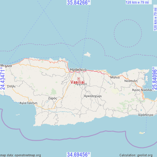
Vasilíai GPS coordinates[2]
35° 16' 14.304" North, 25° 8' 16.188" East
| Map corner | latitude | longitude |
|---|---|---|
| Upper-left | 35.84266°, | 24.43471° |
| Center: | 35.27064°, | 25.13783° |
| Lower-right: | 34.69456°, | 25.84096° |
| Map W x H: | 127.7×127.7 km | = 79.3×79.3mi |
| max Lat: | 41.72048° ⇑97.1% North |
| Vasilíai: | 35.27064° |
| min Lat: | ⇓2.9% South 34.8346° |
| min Long | Vasilíai | max Long |
| 19.40494° | 25.13783° | 29.59361° |
| W 88.1%⇐ | ⇒11.9% E |
Elevation
Elevation of Vasilíai is 307 m = 1007 ft, and this is 138.1 m = 453 ft above average elevation for this country.
| Max E: |
1439 m = 4721 ft | 18.6% |
| Vasilíai | 307 m 1007 ft | |
| Avg. | 168.9 m = 554 ft | |
Min E: |
0 m = 0 ft | 81.4% |
See also: Greece elevation on elevation.city.
Geographical zone
Vasilíai is located in North temperate zone (between Tropic of Cancer and the Arctic Circle). Distance of this Northern Tropic circle is 1315.8 km =817.6 mi to South.| Distance of | km | miles | from Vasilíai |
|---|---|---|---|
| North Pole | 6085.3 | 3781.2 | to North |
| Arctic Circle | 3479.4 | 2162 | to North |
| Tropic Cancer | 1315.8 | 817.6 | to South |
| Equator | 3921.7 | 2436.8 | to South |


Nearby cities:
15 places around Vasilíai: (largest is in red/bold)
• Ano Arhanes
4.9 km =3 mi,  147°
147°
• Eliá
9.2 km =5.7 mi,  67°
67°
• Episkopí
9.2 km =5.7 mi,  99°
99°
• Gázi
8.9 km =5.5 mi,  313°
313°
• Irákleion
6.4 km =4 mi,  4°
4°
• Karterós
9.1 km =5.7 mi,  43°
43°
• Kavrochóri
9.3 km =5.8 mi,  296°
296°
• Káto Kalésia
7.6 km =4.7 mi,  283°
283°
• Néa Alikarnassós
7.9 km =4.9 mi,  13°
13°
• Profítis Ilías
8 km =5 mi,  205°
205°
• Skalánion
4.6 km =2.9 mi, 73°
• Vatheianós Kámpos
11.2 km =7 mi,  59°
59°
• Ágioi Theódoroi
6.8 km =4.2 mi,  323°
323°
• Áno Kalésia
7.3 km =4.5 mi, 281°
• Áyiai Paraskiaí
9.1 km =5.7 mi,  138°
138°
Sources, notices
• [Note1] Compared only with cities in Greece existing in our database
• [Src1] Map data: © OpenStreetMap contributors (CC-BY-SA)
• [Src2] Other city data from geonames.org with taken over terms of usage.
• [Src3] Geographical zone / Annual Mean Temperature by Robert A. Rohde @ Wikipedia
