Skalánion geodata
Skalánion (Crete) is a populated place; located in Greece in Europe/Athens (GMT+3) time zone. With population of 1,012 people, there are 1004 cities with bigger population in this country. Compared to other cities in Greece, 97% of cities are located further ↑North; 88.6% of cities are located further ←West and 77.5% of cities have lower elevation than Skalánion. Note1


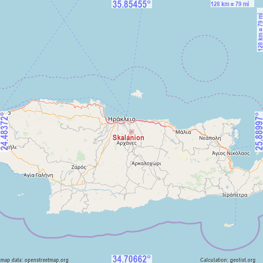
Skalánion GPS coordinates[2]
35° 16' 57.432" North, 25° 11' 12.624" East
| Map corner | latitude | longitude |
|---|---|---|
| Upper-left | 35.85455°, | 24.48372° |
| Center: | 35.28262°, | 25.18684° |
| Lower-right: | 34.70662°, | 25.88997° |
| Map W x H: | 127.6×127.6 km | = 79.3×79.3mi |
| max Lat: | 41.72048° ⇑97% North |
| Skalánion: | 35.28262° |
| min Lat: | ⇓3% South 34.8346° |
| min Long | Skalánion | max Long |
| 19.40494° | 25.18684° | 29.59361° |
| W 88.6%⇐ | ⇒11.4% E |
Elevation
Elevation of Skalánion is 242 m = 794 ft, and this is 73.1 m = 240 ft above average elevation for this country.
| Max E: |
1439 m = 4721 ft | 22.5% |
| Skalánion | 242 m 794 ft | |
| Avg. | 168.9 m = 554 ft | |
Min E: |
0 m = 0 ft | 77.5% |
See also: Greece elevation on elevation.city.
Geographical zone
Skalánion is located in North temperate zone (between Tropic of Cancer and the Arctic Circle). Distance of this Northern Tropic circle is 1317.1 km =818.4 mi to South.| Distance of | km | miles | from Skalánion |
|---|---|---|---|
| North Pole | 6084 | 3780.4 | to North |
| Arctic Circle | 3478.1 | 2161.2 | to North |
| Tropic Cancer | 1317.1 | 818.4 | to South |
| Equator | 3923.1 | 2437.7 | to South |


Nearby cities:
15 places around Skalánion: (largest is in red/bold)
• Ano Arhanes
5.8 km =3.6 mi,  198°
198°
• Eliá
4.7 km =2.9 mi,  60°
60°
• Episkopí
5.4 km =3.4 mi,  121°
121°
• Goúrnes
9.5 km =5.9 mi, 59°
• Goúves
11.9 km =7.4 mi,  74°
74°
• Irákleion
6.4 km =4 mi,  321°
321°
• Karterós
5.5 km =3.4 mi,  18°
18°
• Kokkíni Cháni
8.2 km =5.1 mi,  51°
51°
• Néa Alikarnassós
6.8 km =4.2 mi,  338°
338°
• Profítis Ilías
11.7 km =7.3 mi,  222°
222°
• Vasilíai
4.6 km =2.9 mi,  253°
253°
• Vatheianós Kámpos
6.7 km =4.2 mi, 50°
• Ágioi Theódoroi
9.4 km =5.8 mi,  295°
295°
• Áno Kalésia
11.6 km =7.2 mi,  270°
270°
• Áyiai Paraskiaí
8.3 km =5.2 mi,  168°
168°
Sources, notices
• [Note1] Compared only with cities in Greece existing in our database
• [Src1] Map data: © OpenStreetMap contributors (CC-BY-SA)
• [Src2] Other city data from geonames.org with taken over terms of usage.
• [Src3] Geographical zone / Annual Mean Temperature by Robert A. Rohde @ Wikipedia
