Távros geodata
Távros (Attica) is a populated place; located in Greece in Europe/Athens (GMT+3) time zone. With population of 14,972 people, there are 111 cities with bigger population in this country. Compared to other cities in Greece, 74.8% of cities are located further ↑North; 69.6% of cities are located further ←West and 75.5% of cities have higher elevation than Távros. Note1
Administrative division(s):
- Level 1: Attica
- Level 2: Nomarchía Athínas
- Level 3: Dimos Moschato-Tavros


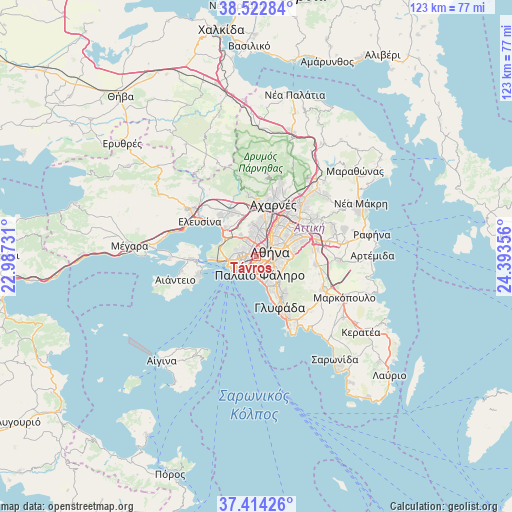
Távros GPS coordinates[2]
37° 58' 14.304" North, 23° 41' 25.548" East
| Map corner | latitude | longitude |
|---|---|---|
| Upper-left | 38.52284°, | 22.98731° |
| Center: | 37.97064°, | 23.69043° |
| Lower-right: | 37.41426°, | 24.39356° |
| Map W x H: | 123.3×123.3 km | = 76.6×76.6mi |
| max Lat: | 41.72048° ⇑74.8% North |
| Távros: | 37.97064° |
| min Lat: | ⇓25.2% South 34.8346° |
| min Long | Távros | max Long |
| 19.40494° | 23.69043° | 29.59361° |
| W 69.6%⇐ | ⇒30.4% E |
Elevation
Elevation of Távros is 23 m = 75 ft, and this is 145.9 m = 479 ft below average elevation for this country.
| Max E: |
1439 m = 4721 ft | 75.5% |
| Avg. | 168.9 m = 554 ft | |
| Távros | 23 m = 75 ft | |
Min E: |
0 m = 0 ft | 24.5% |
See also: Greece elevation on elevation.city.
Geographical zone
Távros is located in North temperate zone (between Tropic of Cancer and the Arctic Circle). Distance of this Northern Tropic circle is 1616 km =1004.1 mi to South.| Distance of | km | miles | from Távros |
|---|---|---|---|
| North Pole | 5785.1 | 3594.7 | to North |
| Arctic Circle | 3179.2 | 1975.5 | to North |
| Tropic Cancer | 1616 | 1004.1 | to South |
| Equator | 4221.9 | 2623.4 | to South |


Nearby cities:
15 places around Távros: (largest is in red/bold)
• Agios Ioannis Rentis
2.3 km =1.4 mi,  253°
253°
• Agía Varvára
3.4 km =2.1 mi,  308°
308°
• Aigáleo
1.5 km =0.9 mi,  336°
336°
• Athens
3.6 km =2.2 mi,  66°
66°
• Chaïdári
5 km =3.1 mi,  334°
334°
• Dhafní
4.5 km =2.8 mi,  120°
120°
• Kallithéa
2.4 km =1.5 mi,  159°
159°
• Kolonaki
4.5 km =2.8 mi,  78°
78°
• Korydallós
4.1 km =2.5 mi,  292°
292°
• Moskháton
2.7 km =1.7 mi,  201°
201°
• Néa Smýrni
3.5 km =2.2 mi,  143°
143°
• Níkaia
3.6 km =2.2 mi,  262°
262°
• Palaió Fáliro
4.8 km =3 mi,  168°
168°
• Peristéri
5 km =3.1 mi,  1°
1°
• Piraeus
5 km =3.1 mi,  230°
230°
Sources, notices
• [Note1] Compared only with cities in Greece existing in our database
• [Src1] Map data: © OpenStreetMap contributors (CC-BY-SA)
• [Src2] Other city data from geonames.org with taken over terms of usage.
• [Src3] Geographical zone / Annual Mean Temperature by Robert A. Rohde @ Wikipedia
