Polichnítos geodata
Polichnítos (North Aegean) is a populated place; located in Greece in Europe/Athens (GMT+3) time zone. With population of 2,667 people, there are 394 cities with bigger population in this country. Compared to other cities in Greece, 53.5% of cities are located further ↑North; 94.5% of cities are located further ←West and 58.8% of cities have lower elevation than Polichnítos. Note1


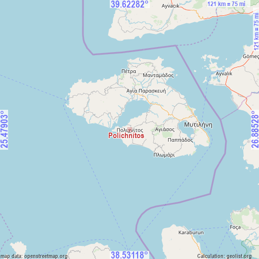
Polichnítos GPS coordinates[2]
39° 4' 44.796" North, 26° 10' 55.74" East
| Map corner | latitude | longitude |
|---|---|---|
| Upper-left | 39.62282°, | 25.47903° |
| Center: | 39.07911°, | 26.18215° |
| Lower-right: | 38.53118°, | 26.88528° |
| Map W x H: | 121.4×121.4 km | = 75.4×75.4mi |
| max Lat: | 41.72048° ⇑53.5% North |
| Polichnítos: | 39.07911° |
| min Lat: | ⇓46.5% South 34.8346° |
| min Long | Polichnítos | max Long |
| 19.40494° | 26.18215° | 29.59361° |
| W 94.5%⇐ | ⇒5.5% E |
Elevation
Elevation of Polichnítos is 112 m = 367 ft, and this is 56.9 m = 187 ft below average elevation for this country.
| Max E: |
1439 m = 4721 ft | 41.2% |
| Avg. | 168.9 m = 554 ft | |
| Polichnítos | 112 m = 367 ft | |
Min E: |
0 m = 0 ft | 58.8% |
See also: Greece elevation on elevation.city.
Geographical zone
Polichnítos is located in North temperate zone (between Tropic of Cancer and the Arctic Circle). Distance of this Northern Tropic circle is 1739.3 km =1080.8 mi to South.| Distance of | km | miles | from Polichnítos |
|---|---|---|---|
| North Pole | 5661.9 | 3518.1 | to North |
| Arctic Circle | 3056 | 1898.9 | to North |
| Tropic Cancer | 1739.3 | 1080.8 | to South |
| Equator | 4345.2 | 2700 | to South |


Nearby cities:
15 places around Polichnítos: (largest is in red/bold)
• Agiásos
16.4 km =10.2 mi,  88°
88°
• Agía Paraskeví
20.3 km =12.6 mi,  22°
22°
• Dáfia
18.2 km =11.3 mi,  4°
4°
• Fília
20.7 km =12.9 mi,  349°
349°
• Kalloní
17.3 km =10.7 mi,  7°
7°
• Kerámion
15.4 km =9.6 mi, 8°
• Káto Trítos
21.7 km =13.5 mi, 87°
• Mesótopos
16.4 km =10.2 mi,  290°
290°
• Parákoila
10.7 km =6.6 mi,  340°
340°
• Plagiá
21.4 km =13.3 mi,  120°
120°
• Plomári
20 km =12.4 mi,  125°
125°
• Skalokhóri
22 km =13.7 mi, 335°
• Vatoússa
19.8 km =12.3 mi,  325°
325°
• Vrísa
4.6 km =2.9 mi,  159°
159°
• Ágra
13.6 km =8.5 mi,  309°
309°
Sources, notices
• [Note1] Compared only with cities in Greece existing in our database
• [Src1] Map data: © OpenStreetMap contributors (CC-BY-SA)
• [Src2] Other city data from geonames.org with taken over terms of usage.
• [Src3] Geographical zone / Annual Mean Temperature by Robert A. Rohde @ Wikipedia
