Longádes geodata
Longádes (Epirus) is a populated place; located in Greece in Europe/Athens (GMT+3) time zone. With population of 859 people, there are 1187 cities with bigger population in this country. Compared to other cities in Greece, 61.7% of cities are located further ↓South; 90.6% of cities are located further →East and 90.2% of cities have lower elevation than Longádes. Note1


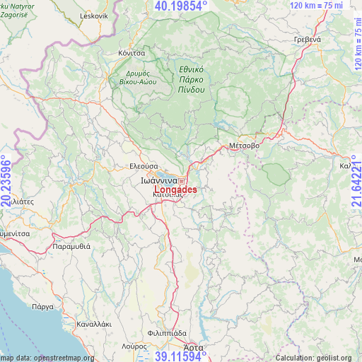
Longádes GPS coordinates[2]
39° 39' 33.696" North, 20° 56' 20.688" East
| Map corner | latitude | longitude |
|---|---|---|
| Upper-left | 40.19854°, | 20.23596° |
| Center: | 39.65936°, | 20.93908° |
| Lower-right: | 39.11594°, | 21.64221° |
| Map W x H: | 120.4×120.4 km | = 74.8×74.8mi |
| max Lat: | 41.72048° ⇑38.3% North |
| Longádes: | 39.65936° |
| min Lat: | ⇓61.7% South 34.8346° |
| min Long | Longádes | max Long |
| 19.40494° | 20.93908° | 29.59361° |
| W 9.4%⇐ | ⇒90.6% E |
Elevation
Elevation of Longádes is 507 m = 1663 ft, and this is 338.1 m = 1109 ft above average elevation for this country.
| Max E: |
1439 m = 4721 ft | 9.8% |
| Longádes | 507 m 1663 ft | |
| Avg. | 168.9 m = 554 ft | |
Min E: |
0 m = 0 ft | 90.2% |
See also: Greece elevation on elevation.city.
Geographical zone
Longádes is located in North temperate zone (between Tropic of Cancer and the Arctic Circle). Distance of this Northern Tropic circle is 1803.8 km =1120.8 mi to South.| Distance of | km | miles | from Longádes |
|---|---|---|---|
| North Pole | 5597.4 | 3478.1 | to North |
| Arctic Circle | 2991.5 | 1858.8 | to North |
| Tropic Cancer | 1803.8 | 1120.8 | to South |
| Equator | 4409.7 | 2740.1 | to South |


Nearby cities:
15 places around Longádes: (largest is in red/bold)
• Amfithéa
7.2 km =4.5 mi,  299°
299°
• Anatolí
6.8 km =4.2 mi,  246°
246°
• Báfra
8.7 km =5.4 mi,  219°
219°
• Drosochóri
4.5 km =2.8 mi,  141°
141°
• Iliókali
5.2 km =3.2 mi,  152°
152°
• Ioánnina
7.5 km =4.7 mi,  274°
274°
• Kastrítsa
3.5 km =2.2 mi,  204°
204°
• Katsikás
6 km =3.7 mi,  227°
227°
• Koutselió
8.3 km =5.2 mi, 196°
• Káto Neochorópoulo
8.7 km =5.4 mi,  255°
255°
• Neochorópoulo
9.6 km =6 mi, 247°
• Pentéli
8.8 km =5.5 mi, 274°
• Pérama
8.8 km =5.5 mi, 295°
• Tsiflikópoulo
8.6 km =5.3 mi, 267°
• Velissários
8.6 km =5.3 mi, 263°
Sources, notices
• [Note1] Compared only with cities in Greece existing in our database
• [Src1] Map data: © OpenStreetMap contributors (CC-BY-SA)
• [Src2] Other city data from geonames.org with taken over terms of usage.
• [Src3] Geographical zone / Annual Mean Temperature by Robert A. Rohde @ Wikipedia
