Pérama geodata
Pérama (Epirus) is a populated place; located in Greece in Europe/Athens (GMT+3) time zone. With population of 1,841 people, there are 561 cities with bigger population in this country. Compared to other cities in Greece, 62.7% of cities are located further ↓South; 92.5% of cities are located further →East and 88.5% of cities have lower elevation than Pérama. Note1


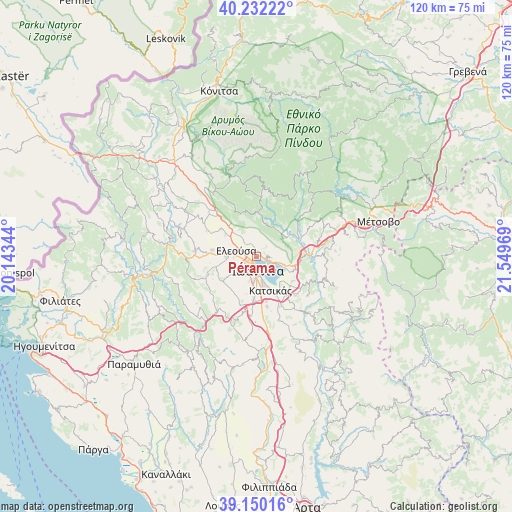
Pérama GPS coordinates[2]
39° 41' 35.916" North, 20° 50' 47.616" East
| Map corner | latitude | longitude |
|---|---|---|
| Upper-left | 40.23222°, | 20.14344° |
| Center: | 39.69331°, | 20.84656° |
| Lower-right: | 39.15016°, | 21.54969° |
| Map W x H: | 120.3×120.3 km | = 74.8×74.8mi |
| max Lat: | 41.72048° ⇑37.3% North |
| Pérama: | 39.69331° |
| min Lat: | ⇓62.7% South 34.8346° |
| min Long | Pérama | max Long |
| 19.40494° | 20.84656° | 29.59361° |
| W 7.5%⇐ | ⇒92.5% E |
Elevation
Elevation of Pérama is 476 m = 1562 ft, and this is 307.1 m = 1008 ft above average elevation for this country.
| Max E: |
1439 m = 4721 ft | 11.5% |
| Pérama | 476 m 1562 ft | |
| Avg. | 168.9 m = 554 ft | |
Min E: |
0 m = 0 ft | 88.5% |
See also: Greece elevation on elevation.city.
Geographical zone
Pérama is located in North temperate zone (between Tropic of Cancer and the Arctic Circle). Distance of this Northern Tropic circle is 1807.6 km =1123.2 mi to South.| Distance of | km | miles | from Pérama |
|---|---|---|---|
| North Pole | 5593.6 | 3475.7 | to North |
| Arctic Circle | 2987.7 | 1856.5 | to North |
| Tropic Cancer | 1807.6 | 1123.2 | to South |
| Equator | 4413.5 | 2742.4 | to South |


Nearby cities:
15 places around Pérama: (largest is in red/bold)
• Amfithéa
1.6 km =1 mi,  98°
98°
• Anatolí
6.7 km =4.2 mi,  165°
165°
• Eksochí
2.2 km =1.4 mi,  252°
252°
• Eleoúsa
4.8 km =3 mi,  287°
287°
• Ioánnina
3.2 km =2 mi, 171°
• Kardamítsia
2.9 km =1.8 mi,  233°
233°
• Káto Mármara
5.8 km =3.6 mi,  195°
195°
• Káto Neochorópoulo
5.9 km =3.7 mi,  184°
184°
• Mármara
6.1 km =3.8 mi, 225°
• Pentéli
3.2 km =2 mi, 195°
• Stavráki
4.8 km =3 mi,  210°
210°
• Tsiflikópoulo
4.2 km =2.6 mi,  189°
189°
• Velissários
4.8 km =3 mi, 187°
• Vounoplagiá
5.2 km =3.2 mi,  267°
267°
• Ágios Ioánnis
2.9 km =1.8 mi,  277°
277°
Sources, notices
• [Note1] Compared only with cities in Greece existing in our database
• [Src1] Map data: © OpenStreetMap contributors (CC-BY-SA)
• [Src2] Other city data from geonames.org with taken over terms of usage.
• [Src3] Geographical zone / Annual Mean Temperature by Robert A. Rohde @ Wikipedia
