Metamórfosi geodata
Metamórfosi (Attica) is a seat of a third-order administrative division; located in Greece in Europe/Athens (GMT+3) time zone. With population of 29,891 people, there are 64 cities with bigger population in this country. Compared to other cities in Greece, 71% of cities are located further ↑North; 71.9% of cities are located further ←West and 70.9% of cities have lower elevation than Metamórfosi. Note1


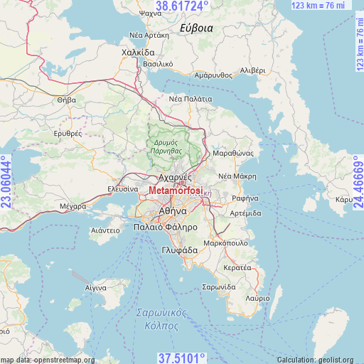
Metamórfosi GPS coordinates[2]
38° 3' 56.736" North, 23° 45' 48.816" East
| Map corner | latitude | longitude |
|---|---|---|
| Upper-left | 38.61724°, | 23.06044° |
| Center: | 38.06576°, | 23.76356° |
| Lower-right: | 37.5101°, | 24.46669° |
| Map W x H: | 123.1×123.1 km | = 76.5×76.5mi |
| max Lat: | 41.72048° ⇑71% North |
| Metamórfosi: | 38.06576° |
| min Lat: | ⇓29% South 34.8346° |
| min Long | Metamórfosi | max Long |
| 19.40494° | 23.76356° | 29.59361° |
| W 71.9%⇐ | ⇒28.1% E |
Elevation
Elevation of Metamórfosi is 173 m = 568 ft, and this is 4.1 m = 13 ft above average elevation for this country.
| Max E: |
1439 m = 4721 ft | 29.1% |
| Metamórfosi | 173 m 568 ft | |
| Avg. | 168.9 m = 554 ft | |
Min E: |
0 m = 0 ft | 70.9% |
See also: Greece elevation on elevation.city.
Geographical zone
Metamórfosi is located in North temperate zone (between Tropic of Cancer and the Arctic Circle). Distance of this Northern Tropic circle is 1626.6 km =1010.7 mi to South.| Distance of | km | miles | from Metamórfosi |
|---|---|---|---|
| North Pole | 5774.5 | 3588.1 | to North |
| Arctic Circle | 3168.7 | 1968.9 | to North |
| Tropic Cancer | 1626.6 | 1010.7 | to South |
| Equator | 4232.5 | 2630 | to South |


Nearby cities:
15 places around Metamórfosi: (largest is in red/bold)
• Acharnés
3.3 km =2.1 mi,  306°
306°
• Filothéi
4.8 km =3 mi,  159°
159°
• Galátsi
5.6 km =3.5 mi,  192°
192°
• Irákleio
1.4 km =0.9 mi,  174°
174°
• Kamaterón
5.2 km =3.2 mi,  257°
257°
• Khalándrion
5.7 km =3.5 mi,  145°
145°
• Kifisiá
4.3 km =2.7 mi,  77°
77°
• Lykóvrysi
1.7 km =1.1 mi, 76°
• Maroúsi
3.6 km =2.2 mi,  118°
118°
• Néa Chalkidóna
5.2 km =3.2 mi,  213°
213°
• Néa Filadélfeia
4.1 km =2.5 mi, 213°
• Néa Ionía
3.4 km =2.1 mi, 189°
• Péfki
2.6 km =1.6 mi,  103°
103°
• Zefyri
4.1 km =2.5 mi,  271°
271°
• Ágioi Anárgyroi
5.3 km =3.3 mi,  221°
221°
Sources, notices
• [Note1] Compared only with cities in Greece existing in our database
• [Src1] Map data: © OpenStreetMap contributors (CC-BY-SA)
• [Src2] Other city data from geonames.org with taken over terms of usage.
• [Src3] Geographical zone / Annual Mean Temperature by Robert A. Rohde @ Wikipedia
