Irákleio geodata
Irákleio (Attica) is a seat of a third-order administrative division; located in Greece in Europe/Athens (GMT+3) time zone. With population of 49,642 people, there are 40 cities with bigger population in this country. Compared to other cities in Greece, 71.4% of cities are located further ↑North; 71.9% of cities are located further ←West and 70.5% of cities have lower elevation than Irákleio. Note1


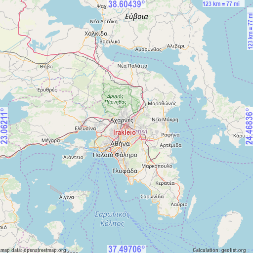
Irákleio GPS coordinates[2]
38° 3' 10.152" North, 23° 45' 54.828" East
| Map corner | latitude | longitude |
|---|---|---|
| Upper-left | 38.60439°, | 23.06211° |
| Center: | 38.05282°, | 23.76523° |
| Lower-right: | 37.49706°, | 24.46836° |
| Map W x H: | 123.1×123.1 km | = 76.5×76.5mi |
| max Lat: | 41.72048° ⇑71.4% North |
| Irákleio: | 38.05282° |
| min Lat: | ⇓28.6% South 34.8346° |
| min Long | Irákleio | max Long |
| 19.40494° | 23.76523° | 29.59361° |
| W 71.9%⇐ | ⇒28.1% E |
Elevation
Elevation of Irákleio is 169 m = 554 ft, and this is 0.099999999999994 m = 0 ft above average elevation for this country.
| Max E: |
1439 m = 4721 ft | 29.5% |
| Irákleio | 169 m 554 ft | |
| Avg. | 168.9 m = 554 ft | |
Min E: |
0 m = 0 ft | 70.5% |
See also: Irákleio elevation on elevation.city.
Geographical zone
Irákleio is located in North temperate zone (between Tropic of Cancer and the Arctic Circle). Distance of this Northern Tropic circle is 1625.2 km =1009.9 mi to South.| Distance of | km | miles | from Irákleio |
|---|---|---|---|
| North Pole | 5776 | 3589 | to North |
| Arctic Circle | 3170.1 | 1969.8 | to North |
| Tropic Cancer | 1625.2 | 1009.9 | to South |
| Equator | 4231.1 | 2629.1 | to South |


Nearby cities:
15 places around Irákleio: (largest is in red/bold)
• Acharnés
4.4 km =2.7 mi,  320°
320°
• Filothéi
3.4 km =2.1 mi,  153°
153°
• Galátsi
4.2 km =2.6 mi,  198°
198°
• Khalándrion
4.5 km =2.8 mi,  136°
136°
• Kifisiá
4.7 km =2.9 mi,  59°
59°
• Lykóvrysi
2.4 km =1.5 mi,  39°
39°
• Maroúsi
3.1 km =1.9 mi,  95°
95°
• Metamórfosi
1.4 km =0.9 mi,  354°
354°
• Néa Chalkidóna
4.2 km =2.6 mi,  226°
226°
• Néa Filadélfeia
3.1 km =1.9 mi, 230°
• Néa Ionía
2 km =1.2 mi, 199°
• Psychikó
4.4 km =2.7 mi,  172°
172°
• Péfki
2.5 km =1.6 mi,  71°
71°
• Zefyri
4.5 km =2.8 mi,  289°
289°
• Ágioi Anárgyroi
4.4 km =2.7 mi,  235°
235°
Sources, notices
• [Note1] Compared only with cities in Greece existing in our database
• [Src1] Map data: © OpenStreetMap contributors (CC-BY-SA)
• [Src2] Other city data from geonames.org with taken over terms of usage.
• [Src3] Geographical zone / Annual Mean Temperature by Robert A. Rohde @ Wikipedia
