Kipséli geodata
Kipséli (Attica) is a section of populated place; located in Greece in Europe/Athens (GMT+3) time zone. With population of 2,096 people, there are 494 cities with bigger population in this country. Compared to other cities in Greece, 73.6% of cities are located further ↑North; 71% of cities are located further ←West and 62% of cities have lower elevation than Kipséli. Note1


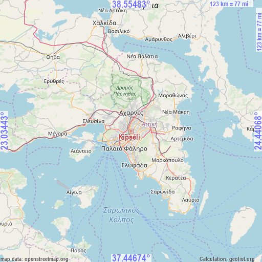
Kipséli GPS coordinates[2]
38° 0' 10.368" North, 23° 44' 15.18" East
| Map corner | latitude | longitude |
|---|---|---|
| Upper-left | 38.55483°, | 23.03443° |
| Center: | 38.00288°, | 23.73755° |
| Lower-right: | 37.44674°, | 24.44068° |
| Map W x H: | 123.2×123.2 km | = 76.6×76.6mi |
| max Lat: | 41.72048° ⇑73.6% North |
| Kipséli: | 38.00288° |
| min Lat: | ⇓26.4% South 34.8346° |
| min Long | Kipséli | max Long |
| 19.40494° | 23.73755° | 29.59361° |
| W 71%⇐ | ⇒29% E |
Elevation
Elevation of Kipséli is 126 m = 413 ft, and this is 42.9 m = 141 ft below average elevation for this country.
| Max E: |
1439 m = 4721 ft | 38% |
| Avg. | 168.9 m = 554 ft | |
| Kipséli | 126 m = 413 ft | |
Min E: |
0 m = 0 ft | 62% |
See also: Greece elevation on elevation.city.
Geographical zone
Kipséli is located in North temperate zone (between Tropic of Cancer and the Arctic Circle). Distance of this Northern Tropic circle is 1619.6 km =1006.4 mi to South.| Distance of | km | miles | from Kipséli |
|---|---|---|---|
| North Pole | 5781.5 | 3592.5 | to North |
| Arctic Circle | 3175.6 | 1973.2 | to North |
| Tropic Cancer | 1619.6 | 1006.4 | to South |
| Equator | 4225.5 | 2625.6 | to South |


Nearby cities:
15 places around Kipséli: (largest is in red/bold)
• Athens
2.3 km =1.4 mi,  201°
201°
• Filothéi
4.7 km =2.9 mi,  57°
57°
• Galátsi
1.9 km =1.2 mi,  35°
35°
• Kaisarianí
5 km =3.1 mi,  151°
151°
• Kolonaki
2.7 km =1.7 mi,  173°
173°
• Néa Chalkidóna
2.8 km =1.7 mi,  347°
347°
• Néa Filadélfeia
3.6 km =2.2 mi,  0°
0°
• Néa Ionía
4 km =2.5 mi,  25°
25°
• Néo Psychikó
4.1 km =2.5 mi,  84°
84°
• Peristéri
4.2 km =2.6 mi,  289°
289°
• Psychikó
3.2 km =2 mi,  69°
69°
• Výronas
4.8 km =3 mi,  163°
163°
• Zográfos
4.1 km =2.5 mi,  137°
137°
• Ágioi Anárgyroi
3.3 km =2.1 mi,  338°
338°
• Ílion
4.7 km =2.9 mi,  315°
315°
Sources, notices
• [Note1] Compared only with cities in Greece existing in our database
• [Src1] Map data: © OpenStreetMap contributors (CC-BY-SA)
• [Src2] Other city data from geonames.org with taken over terms of usage.
• [Src3] Geographical zone / Annual Mean Temperature by Robert A. Rohde @ Wikipedia
