Zográfos geodata
Zográfos (Attica) is a seat of a second-order administrative division; located in Greece in Europe/Athens (GMT+3) time zone. With population of 71,026 people, there are 20 cities with bigger population in this country. Compared to other cities in Greece, 74.7% of cities are located further ↑North; 72.1% of cities are located further ←West and 71.3% of cities have lower elevation than Zográfos. Note1


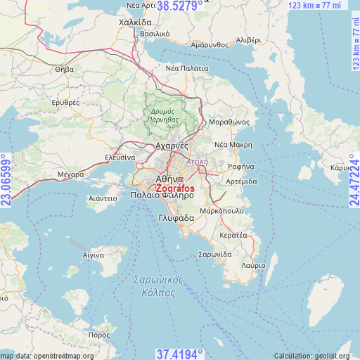
Zográfos GPS coordinates[2]
37° 58' 32.664" North, 23° 46' 8.796" East
| Map corner | latitude | longitude |
|---|---|---|
| Upper-left | 38.5279°, | 23.06599° |
| Center: | 37.97574°, | 23.76911° |
| Lower-right: | 37.4194°, | 24.47224° |
| Map W x H: | 123.3×123.3 km | = 76.6×76.6mi |
| max Lat: | 41.72048° ⇑74.7% North |
| Zográfos: | 37.97574° |
| min Lat: | ⇓25.3% South 34.8346° |
| min Long | Zográfos | max Long |
| 19.40494° | 23.76911° | 29.59361° |
| W 72.1%⇐ | ⇒27.9% E |
Elevation
Elevation of Zográfos is 176 m = 577 ft, and this is 7.1 m = 23 ft above average elevation for this country.
| Max E: |
1439 m = 4721 ft | 28.7% |
| Zográfos | 176 m 577 ft | |
| Avg. | 168.9 m = 554 ft | |
Min E: |
0 m = 0 ft | 71.3% |
See also: Zográfos elevation on elevation.city.
Geographical zone
Zográfos is located in North temperate zone (between Tropic of Cancer and the Arctic Circle). Distance of this Northern Tropic circle is 1616.6 km =1004.5 mi to South.| Distance of | km | miles | from Zográfos |
|---|---|---|---|
| North Pole | 5784.6 | 3594.4 | to North |
| Arctic Circle | 3178.7 | 1975.2 | to North |
| Tropic Cancer | 1616.6 | 1004.5 | to South |
| Equator | 4222.5 | 2623.7 | to South |


Nearby cities:
15 places around Zográfos: (largest is in red/bold)
• Agios Dimitrios
5.7 km =3.5 mi,  213°
213°
• Athens
3.7 km =2.3 mi,  283°
283°
• Cholargós
3.8 km =2.4 mi,  45°
45°
• Dhafní
4.2 km =2.6 mi,  226°
226°
• Filothéi
5.6 km =3.5 mi,  12°
12°
• Galátsi
4.8 km =3 mi,  339°
339°
• Ilioúpoli
4.9 km =3 mi,  181°
181°
• Kaisarianí
1.4 km =0.9 mi,  193°
193°
• Kipséli
4.1 km =2.5 mi,  317°
317°
• Kolonaki
2.5 km =1.6 mi, 277°
• Néo Psychikó
3.6 km =2.2 mi,  20°
20°
• Papágou
2.4 km =1.5 mi,  60°
60°
• Psychikó
4.2 km =2.6 mi,  3°
3°
• Výronas
2.2 km =1.4 mi,  220°
220°
• Ymittos
3 km =1.9 mi, 215°
Sources, notices
• [Note1] Compared only with cities in Greece existing in our database
• [Src1] Map data: © OpenStreetMap contributors (CC-BY-SA)
• [Src2] Other city data from geonames.org with taken over terms of usage.
• [Src3] Geographical zone / Annual Mean Temperature by Robert A. Rohde @ Wikipedia
