Grammatikó geodata
Grammatikó (Attica) is a populated place; located in Greece in Europe/Athens (GMT+3) time zone. With population of 1,432 people, there are 700 cities with bigger population in this country. Compared to other cities in Greece, 68% of cities are located further ↑North; 77.7% of cities are located further ←West and 79.1% of cities have lower elevation than Grammatikó. Note1
Administrative division(s):
- Level 1: Attica
- Level 2: Nomarchía Anatolikís Attikís
- Level 3: Dimos Marathon


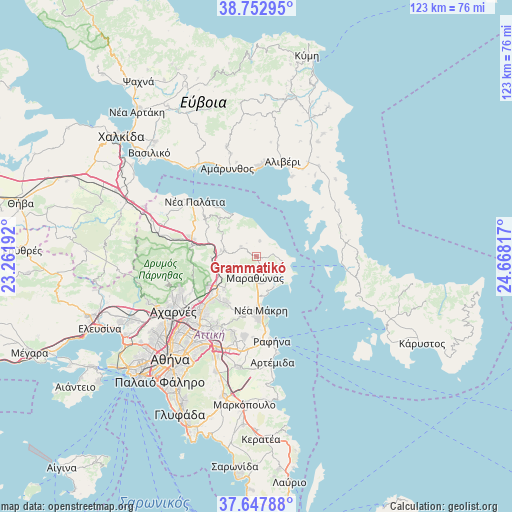
Grammatikó GPS coordinates[2]
38° 12' 9.036" North, 23° 57' 54.144" East
| Map corner | latitude | longitude |
|---|---|---|
| Upper-left | 38.75295°, | 23.26192° |
| Center: | 38.20251°, | 23.96504° |
| Lower-right: | 37.64788°, | 24.66817° |
| Map W x H: | 122.9×122.9 km | = 76.4×76.4mi |
| max Lat: | 41.72048° ⇑68% North |
| Grammatikó: | 38.20251° |
| min Lat: | ⇓32% South 34.8346° |
| min Long | Grammatikó | max Long |
| 19.40494° | 23.96504° | 29.59361° |
| W 77.7%⇐ | ⇒22.3% E |
Elevation
Elevation of Grammatikó is 267 m = 876 ft, and this is 98.1 m = 322 ft above average elevation for this country.
| Max E: |
1439 m = 4721 ft | 20.9% |
| Grammatikó | 267 m 876 ft | |
| Avg. | 168.9 m = 554 ft | |
Min E: |
0 m = 0 ft | 79.1% |
See also: Greece elevation on elevation.city.
Geographical zone
Grammatikó is located in North temperate zone (between Tropic of Cancer and the Arctic Circle). Distance of this Northern Tropic circle is 1641.8 km =1020.2 mi to South.| Distance of | km | miles | from Grammatikó |
|---|---|---|---|
| North Pole | 5759.3 | 3578.7 | to North |
| Arctic Circle | 3153.5 | 1959.5 | to North |
| Tropic Cancer | 1641.8 | 1020.2 | to South |
| Equator | 4247.7 | 2639.4 | to South |


Nearby cities:
15 places around Grammatikó: (largest is in red/bold)
• Afidnés
10.9 km =6.8 mi,  270°
270°
• Aghios Panteleímon
9.7 km =6 mi,  171°
171°
• Anoixi
12.1 km =7.5 mi,  230°
230°
• Drosiá
12.7 km =7.9 mi,  223°
223°
• Kapandríti
7.6 km =4.7 mi,  281°
281°
• Káto Soúlion
5.9 km =3.7 mi,  130°
130°
• Marathónas
5.5 km =3.4 mi,  182°
182°
• Mikrokhórion
7.2 km =4.5 mi,  298°
298°
• Polydéndri
8.6 km =5.3 mi, 280°
• Rodópoli
12.3 km =7.6 mi, 219°
• Stamáta
11.3 km =7 mi, 220°
• Varnávas
4.4 km =2.7 mi, 302°
• Vraná
8.7 km =5.4 mi,  187°
187°
• Ágios Stéfanos
11.4 km =7.1 mi,  236°
236°
• Áyioi Apóstoloi
11 km =6.8 mi,  334°
334°
Sources, notices
• [Note1] Compared only with cities in Greece existing in our database
• [Src1] Map data: © OpenStreetMap contributors (CC-BY-SA)
• [Src2] Other city data from geonames.org with taken over terms of usage.
• [Src3] Geographical zone / Annual Mean Temperature by Robert A. Rohde @ Wikipedia
