Kolokynthoú geodata
Kolokynthoú (West Macedonia) is a populated place; located in Greece in Europe/Athens (GMT+3) time zone. With population of 744 people, there are 1340 cities with bigger population in this country. Compared to other cities in Greece, 75% of cities are located further ↓South; 87.5% of cities are located further →East and 95% of cities have lower elevation than Kolokynthoú. Note1
Administrative division(s):
- Level 1: West Macedonia
- Level 2: Nomós Kastoriás
- Level 3: Dimos Kastoria


Kolokynthoú GPS coordinates[2]
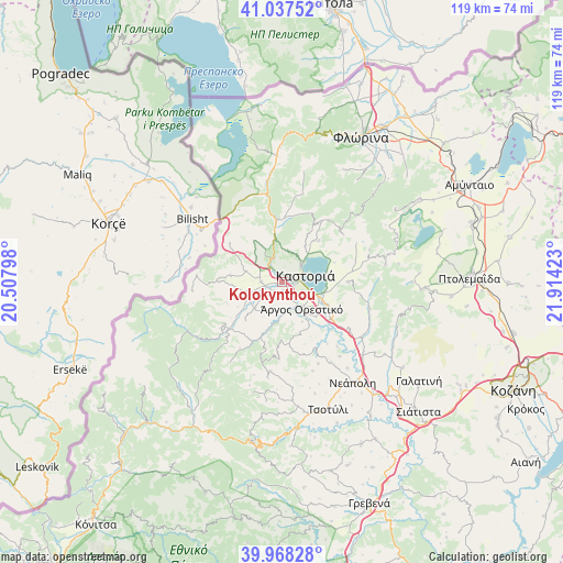
40° 30' 18.108" North, 21° 12' 39.96" East
| Map corner | latitude | longitude |
|---|---|---|
| Upper-left | 41.03752°, | 20.50798° |
| Center: | 40.50503°, | 21.2111° |
| Lower-right: | 39.96828°, | 21.91423° |
| Map W x H: | 118.9×118.9 km | = 73.9×73.9mi |
| max Lat: | 41.72048° ⇑25% North |
| Kolokynthoú: | 40.50503° |
| min Lat: | ⇓75% South 34.8346° |
| min Long | Kolokynthoú | max Long |
| 19.40494° | 21.2111° | 29.59361° |
| W 12.5%⇐ | ⇒87.5% E |
Elevation
Elevation of Kolokynthoú is 667 m = 2188 ft, and this is 498.1 m = 1634 ft above average elevation for this country.
| Max E: |
1439 m = 4721 ft | 5% |
| Kolokynthoú | 667 m 2188 ft | |
| Avg. | 168.9 m = 554 ft | |
Min E: |
0 m = 0 ft | 95% |
See also: Greece elevation on elevation.city.
Geographical zone
Kolokynthoú is located in North temperate zone (between Tropic of Cancer and the Arctic Circle). Distance of this Northern Tropic circle is 1897.8 km =1179.2 mi to South.| Distance of | km | miles | from Kolokynthoú |
|---|---|---|---|
| North Pole | 5503.3 | 3419.6 | to North |
| Arctic Circle | 2897.4 | 1800.4 | to North |
| Tropic Cancer | 1897.8 | 1179.2 | to South |
| Equator | 4503.7 | 2798.5 | to South |


Nearby cities:
15 places around Kolokynthoú: (largest is in red/bold)
• Ampelókipoi
9.4 km =5.8 mi,  117°
117°
• Argos Orestiko
7 km =4.3 mi,  144°
144°
• Chiliódendro
2.6 km =1.6 mi,  220°
220°
• Chlói
5.6 km =3.5 mi,  46°
46°
• Dispilió
7 km =4.3 mi,  111°
111°
• Kastoria
4.8 km =3 mi,  67°
67°
• Maniákoi
2.9 km =1.8 mi,  99°
99°
• Mavrochóri
9.3 km =5.8 mi,  85°
85°
• Mesopotamía
4.2 km =2.6 mi,  266°
266°
• Néa Léfki
2.6 km =1.6 mi, 85°
• Néo Kostarázi
12.8 km =8 mi,  127°
127°
• Pentávryso
8.2 km =5.1 mi,  225°
225°
• Polykárpi
9.5 km =5.9 mi,  78°
78°
• Poreiá
1.8 km =1.1 mi,  176°
176°
• Toichío
11.8 km =7.3 mi,  42°
42°
Sources, notices
• [Note1] Compared only with cities in Greece existing in our database
• [Src1] Map data: © OpenStreetMap contributors (CC-BY-SA)
• [Src2] Other city data from geonames.org with taken over terms of usage.
• [Src3] Geographical zone / Annual Mean Temperature by Robert A. Rohde @ Wikipedia
