Itéa geodata
Itéa (West Macedonia) is a populated place; located in Greece in Europe/Athens (GMT+3) time zone. With population of 542 people, there are 1711 cities with bigger population in this country. Compared to other cities in Greece, 86.7% of cities are located further ↓South; 82.6% of cities are located further →East and 93.3% of cities have lower elevation than Itéa. Note1


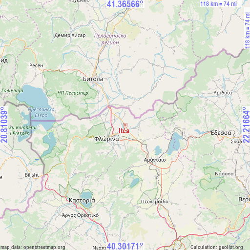
Itéa GPS coordinates[2]
40° 50' 8.952" North, 21° 30' 48.636" East
| Map corner | latitude | longitude |
|---|---|---|
| Upper-left | 41.36566°, | 20.81039° |
| Center: | 40.83582°, | 21.51351° |
| Lower-right: | 40.30171°, | 22.21664° |
| Map W x H: | 118.3×118.3 km | = 73.5×73.5mi |
| max Lat: | 41.72048° ⇑13.3% North |
| Itéa: | 40.83582° |
| min Lat: | ⇓86.7% South 34.8346° |
| min Long | Itéa | max Long |
| 19.40494° | 21.51351° | 29.59361° |
| W 17.4%⇐ | ⇒82.6% E |
Elevation
Elevation of Itéa is 612 m = 2008 ft, and this is 443.1 m = 1454 ft above average elevation for this country.
| Max E: |
1439 m = 4721 ft | 6.7% |
| Itéa | 612 m 2008 ft | |
| Avg. | 168.9 m = 554 ft | |
Min E: |
0 m = 0 ft | 93.3% |
See also: Greece elevation on elevation.city.
Geographical zone
Itéa is located in North temperate zone (between Tropic of Cancer and the Arctic Circle). Distance of this Northern Tropic circle is 1934.6 km =1202.1 mi to South.| Distance of | km | miles | from Itéa |
|---|---|---|---|
| North Pole | 5466.5 | 3396.7 | to North |
| Arctic Circle | 2860.7 | 1777.6 | to North |
| Tropic Cancer | 1934.6 | 1202.1 | to South |
| Equator | 4540.5 | 2821.3 | to South |


Nearby cities:
15 places around Itéa: (largest is in red/bold)
• Aetós
19.7 km =12.2 mi,  170°
170°
• Ammochóri
6.5 km =4 mi,  202°
202°
• Amýntaio
21.4 km =13.3 mi,  139°
139°
• Análipsi
21 km =13 mi, 137°
• Armenokhórion
5.8 km =3.6 mi,  230°
230°
• Flórina
10.6 km =6.6 mi,  235°
235°
• Kélli
15.7 km =9.8 mi,  110°
110°
• Melíti
6 km =3.7 mi,  91°
91°
• Pappagiánnis
1.3 km =0.8 mi,  283°
283°
• Sitariá
5.6 km =3.5 mi,  153°
153°
• Sklíthro
23.8 km =14.8 mi,  181°
181°
• Skopiá
11.8 km =7.3 mi, 227°
• Vévi
11.5 km =7.1 mi,  131°
131°
• Xinó Neró
18.6 km =11.6 mi, 150°
• Ágios Panteleímonas
23.4 km =14.5 mi,  122°
122°
Sources, notices
• [Note1] Compared only with cities in Greece existing in our database
• [Src1] Map data: © OpenStreetMap contributors (CC-BY-SA)
• [Src2] Other city data from geonames.org with taken over terms of usage.
• [Src3] Geographical zone / Annual Mean Temperature by Robert A. Rohde @ Wikipedia
