Ammochóri geodata
Ammochóri (West Macedonia) is a populated place; located in Greece in Europe/Athens (GMT+3) time zone. With population of 1,250 people, there are 805 cities with bigger population in this country. Compared to other cities in Greece, 84.5% of cities are located further ↓South; 83.3% of cities are located further →East and 94% of cities have lower elevation than Ammochóri. Note1


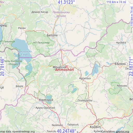
Ammochóri GPS coordinates[2]
40° 46' 55.308" North, 21° 29' 4.488" East
| Map corner | latitude | longitude |
|---|---|---|
| Upper-left | 41.3123°, | 20.78146° |
| Center: | 40.78203°, | 21.48458° |
| Lower-right: | 40.24749°, | 22.18771° |
| Map W x H: | 118.4×118.4 km | = 73.6×73.6mi |
| max Lat: | 41.72048° ⇑15.5% North |
| Ammochóri: | 40.78203° |
| min Lat: | ⇓84.5% South 34.8346° |
| min Long | Ammochóri | max Long |
| 19.40494° | 21.48458° | 29.59361° |
| W 16.7%⇐ | ⇒83.3% E |
Elevation
Elevation of Ammochóri is 634 m = 2080 ft, and this is 465.1 m = 1526 ft above average elevation for this country.
| Max E: |
1439 m = 4721 ft | 6% |
| Ammochóri | 634 m 2080 ft | |
| Avg. | 168.9 m = 554 ft | |
Min E: |
0 m = 0 ft | 94% |
See also: Greece elevation on elevation.city.
Geographical zone
Ammochóri is located in North temperate zone (between Tropic of Cancer and the Arctic Circle). Distance of this Northern Tropic circle is 1928.6 km =1198.4 mi to South.| Distance of | km | miles | from Ammochóri |
|---|---|---|---|
| North Pole | 5472.5 | 3400.5 | to North |
| Arctic Circle | 2866.6 | 1781.2 | to North |
| Tropic Cancer | 1928.6 | 1198.4 | to South |
| Equator | 4534.5 | 2817.6 | to South |


Nearby cities:
15 places around Ammochóri: (largest is in red/bold)
• Aetós
14.7 km =9.1 mi,  156°
156°
• Amýntaio
19.4 km =12.1 mi,  121°
121°
• Análipsi
19.2 km =11.9 mi, 119°
• Armenokhórion
3 km =1.9 mi,  318°
318°
• Flórina
6.3 km =3.9 mi,  269°
269°
• Itéa
6.5 km =4 mi,  22°
22°
• Kélli
17.2 km =10.7 mi,  88°
88°
• Léchovo
22 km =13.7 mi,  178°
178°
• Melíti
10.2 km =6.3 mi,  55°
55°
• Pappagiánnis
6.4 km =4 mi,  10°
10°
• Sitariá
5 km =3.1 mi,  78°
78°
• Sklíthro
17.9 km =11.1 mi,  174°
174°
• Skopiá
6.6 km =4.1 mi,  251°
251°
• Vévi
11.2 km =7 mi,  98°
98°
• Xinó Neró
15.5 km =9.6 mi,  131°
131°
Sources, notices
• [Note1] Compared only with cities in Greece existing in our database
• [Src1] Map data: © OpenStreetMap contributors (CC-BY-SA)
• [Src2] Other city data from geonames.org with taken over terms of usage.
• [Src3] Geographical zone / Annual Mean Temperature by Robert A. Rohde @ Wikipedia
