Aridaía geodata
Aridaía (Central Macedonia) is a seat of a third-order administrative division; located in Greece in Europe/Athens (GMT+3) time zone. With population of 6,561 people, there are 194 cities with bigger population in this country. Compared to other cities in Greece, 91.1% of cities are located further ↓South; 70.8% of cities are located further →East and 61.1% of cities have lower elevation than Aridaía. Note1


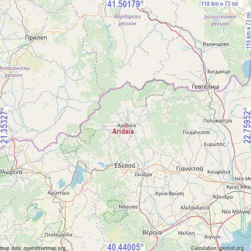
Aridaía GPS coordinates[2]
40° 58' 23.016" North, 22° 3' 23.004" East
| Map corner | latitude | longitude |
|---|---|---|
| Upper-left | 41.50179°, | 21.35327° |
| Center: | 40.97306°, | 22.05639° |
| Lower-right: | 40.44005°, | 22.75952° |
| Map W x H: | 118.1×118.1 km | = 73.4×73.4mi |
| max Lat: | 41.72048° ⇑8.9% North |
| Aridaía: | 40.97306° |
| min Lat: | ⇓91.1% South 34.8346° |
| min Long | Aridaía | max Long |
| 19.40494° | 22.05639° | 29.59361° |
| W 29.2%⇐ | ⇒70.8% E |
Elevation
Elevation of Aridaía is 122 m = 400 ft, and this is 46.9 m = 154 ft below average elevation for this country.
| Max E: |
1439 m = 4721 ft | 38.9% |
| Avg. | 168.9 m = 554 ft | |
| Aridaía | 122 m = 400 ft | |
Min E: |
0 m = 0 ft | 61.1% |
See also: Greece elevation on elevation.city.
Geographical zone
Aridaía is located in North temperate zone (between Tropic of Cancer and the Arctic Circle). Distance of this Northern Tropic circle is 1949.9 km =1211.6 mi to South.| Distance of | km | miles | from Aridaía |
|---|---|---|---|
| North Pole | 5451.3 | 3387.3 | to North |
| Arctic Circle | 2845.4 | 1768 | to North |
| Tropic Cancer | 1949.9 | 1211.6 | to South |
| Equator | 4555.8 | 2830.8 | to South |


Nearby cities:
15 places around Aridaía: (largest is in red/bold)
• Dorothéa
2.4 km =1.5 mi,  2°
2°
• Exaplátanos
6.2 km =3.9 mi,  86°
86°
• Filóteia
10.5 km =6.5 mi,  49°
49°
• Garéfeion
6.1 km =3.8 mi,  352°
352°
• Konstantía
10.2 km =6.3 mi,  73°
73°
• Loutráki
9.2 km =5.7 mi,  268°
268°
• Miliá
7.7 km =4.8 mi, 74°
• Piperiés
3.3 km =2.1 mi,  264°
264°
• Polykárpi
6.2 km =3.9 mi,  212°
212°
• Prómachoi
7.3 km =4.5 mi,  323°
323°
• Sosándra
3.5 km =2.2 mi,  325°
325°
• Tsákoi
2.6 km =1.6 mi,  218°
218°
• Voreinó
6.4 km =4 mi,  17°
17°
• Xifianí
5.2 km =3.2 mi,  157°
157°
• Ápsalos
9 km =5.6 mi,  179°
179°
Sources, notices
• [Note1] Compared only with cities in Greece existing in our database
• [Src1] Map data: © OpenStreetMap contributors (CC-BY-SA)
• [Src2] Other city data from geonames.org with taken over terms of usage.
• [Src3] Geographical zone / Annual Mean Temperature by Robert A. Rohde @ Wikipedia
