Exaplátanos geodata
Exaplátanos (Central Macedonia) is a populated place; located in Greece in Europe/Athens (GMT+3) time zone. With population of 1,292 people, there are 781 cities with bigger population in this country. Compared to other cities in Greece, 91.2% of cities are located further ↓South; 69% of cities are located further →East and 61.4% of cities have lower elevation than Exaplátanos. Note1


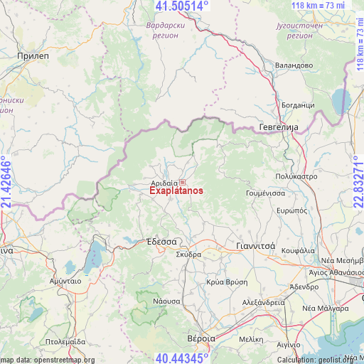
Exaplátanos GPS coordinates[2]
40° 58' 35.148" North, 22° 7' 46.488" East
| Map corner | latitude | longitude |
|---|---|---|
| Upper-left | 41.50514°, | 21.42646° |
| Center: | 40.97643°, | 22.12958° |
| Lower-right: | 40.44345°, | 22.83271° |
| Map W x H: | 118×118 km | = 73.3×73.3mi |
| max Lat: | 41.72048° ⇑8.8% North |
| Exaplátanos: | 40.97643° |
| min Lat: | ⇓91.2% South 34.8346° |
| min Long | Exaplátanos | max Long |
| 19.40494° | 22.12958° | 29.59361° |
| W 31%⇐ | ⇒69% E |
Elevation
Elevation of Exaplátanos is 123 m = 404 ft, and this is 45.9 m = 151 ft below average elevation for this country.
| Max E: |
1439 m = 4721 ft | 38.6% |
| Avg. | 168.9 m = 554 ft | |
| Exaplátanos | 123 m = 404 ft | |
Min E: |
0 m = 0 ft | 61.4% |
See also: Greece elevation on elevation.city.
Geographical zone
Exaplátanos is located in North temperate zone (between Tropic of Cancer and the Arctic Circle). Distance of this Northern Tropic circle is 1950.2 km =1211.8 mi to South.| Distance of | km | miles | from Exaplátanos |
|---|---|---|---|
| North Pole | 5450.9 | 3387 | to North |
| Arctic Circle | 2845 | 1767.8 | to North |
| Tropic Cancer | 1950.2 | 1211.8 | to South |
| Equator | 4556.2 | 2831.1 | to South |


Nearby cities:
15 places around Exaplátanos: (largest is in red/bold)
• Aridaía
6.2 km =3.9 mi,  266°
266°
• Dorothéa
6.4 km =4 mi,  288°
288°
• Filóteia
6.7 km =4.2 mi,  16°
16°
• Garéfeion
9 km =5.6 mi,  309°
309°
• Konstantía
4.4 km =2.7 mi,  56°
56°
• Miliá
2.1 km =1.3 mi,  36°
36°
• Piperiés
9.5 km =5.9 mi, 265°
• Polykárpi
11 km =6.8 mi,  239°
239°
• Sosándra
8.5 km =5.3 mi, 287°
• Theodorákeio
6 km =3.7 mi,  119°
119°
• Tsákoi
8.1 km =5 mi,  252°
252°
• Voreinó
7.1 km =4.4 mi,  323°
323°
• Xifianí
6.6 km =4.1 mi,  218°
218°
• Ápsalos
11.2 km =7 mi,  213°
213°
• Ída
5.4 km =3.4 mi,  46°
46°
Sources, notices
• [Note1] Compared only with cities in Greece existing in our database
• [Src1] Map data: © OpenStreetMap contributors (CC-BY-SA)
• [Src2] Other city data from geonames.org with taken over terms of usage.
• [Src3] Geographical zone / Annual Mean Temperature by Robert A. Rohde @ Wikipedia
