Tai O geodata
Tai O (Islands) is a populated place; located in Hong Kong in Asia/Hong_Kong (GMT+8) time zone. With population of 2,000 people, there are 12 cities with bigger population in this country. Compared to other cities in Hong Kong, 87.5% of cities are located further ↑North; 100% of cities are located further →East and 93.7% of cities have higher elevation than Tai O. Note1


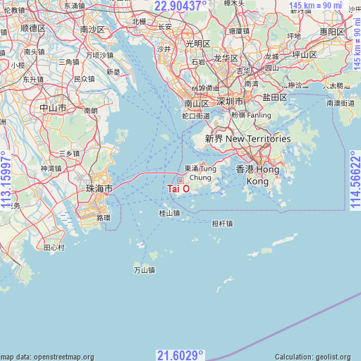
Tai O GPS coordinates[2]
22° 15' 18.54" North, 113° 51' 47.124" East
| Map corner | latitude | longitude |
|---|---|---|
| Upper-left | 22.90437°, | 113.15997° |
| Center: | 22.25515°, | 113.86309° |
| Lower-right: | 21.6029°, | 114.56622° |
| Map W x H: | 144.7×144.7 km | = 89.9×89.9mi |
| max Lat: | 22.45007° ⇑87.5% North |
| Tai O: | 22.25515° |
| min Lat: | ⇓12.5% South 22.20453° |
| min Long | Tai O | max Long |
| 113.86309° | 113.86309° | 114.26667° |
| W 0%⇐ | ⇒100% E |
Elevation
Elevation of Tai O is 4 m = 13 ft, and this is 68.2 m = 224 ft below average elevation for this country.
| Max E: |
435 m = 1427 ft | 93.7% |
| Avg. | 72.2 m = 237 ft | |
| Tai O | 4 m = 13 ft | |
Min E: |
1 m = 3 ft | 6.3% |
See also: Hong Kong elevation on elevation.city.
Geographical zone
Tai O is located in North Torrid zone (between Equator and Tropic of Cancer). Distance of this Northern Tropic circle is 131.4 km =81.6 mi to North.| Distance of | km | miles | from Tai O |
|---|---|---|---|
| North Pole | 7532.5 | 4680.5 | to North |
| Arctic Circle | 4926.6 | 3061.2 | to North |
| Tropic Cancer | 131.4 | 81.6 | to North |
| Equator | 2474.5 | 1537.6 | to South |


Nearby cities:
15 places around Tai O: (largest is in red/bold)
• Central
30.5 km =19 mi,  84°
84°
• Hong Kong
32.2 km =20 mi,  85°
85°
• Kowloon
33.7 km =20.9 mi, 78°
• Ngong Ping
4.2 km =2.6 mi, 89°
• Sha Tin
35.9 km =22.3 mi,  66°
66°
• Sham Shui Po
31.6 km =19.6 mi, 74°
• Sok Kwu Wan
28.2 km =17.5 mi,  101°
101°
• Tai Po
38.2 km =23.7 mi,  55°
55°
• Tsuen Wan
28.8 km =17.9 mi, 63°
• Tuen Mun
18.8 km =11.7 mi,  36°
36°
• Tung Chung
8.9 km =5.5 mi, 66°
• Wan Chai
32 km =19.9 mi, 84°
• Wong Tai Sin
34.6 km =21.5 mi, 72°
• Yuen Long Kau Hui
27.9 km =17.3 mi, 38°
• Yung Shue Wan
25.9 km =16.1 mi, 97°
Sources, notices
• [Note1] Compared only with cities in Hong Kong existing in our database
• [Src1] Map data: © OpenStreetMap contributors (CC-BY-SA)
• [Src2] Other city data from geonames.org with taken over terms of usage.
• [Src3] Geographical zone / Annual Mean Temperature by Robert A. Rohde @ Wikipedia
