Cofradía geodata
Cofradía (Francisco Morazán) is a populated place; located in Honduras in America/Tegucigalpa (GMT-6) time zone. With population of 1,301 people, there are 292 cities with bigger population in this country. Compared to other cities in Honduras, 80.6% of cities are located further ↑North; 67% of cities are located further ←West and 88.8% of cities have lower elevation than Cofradía. Note1


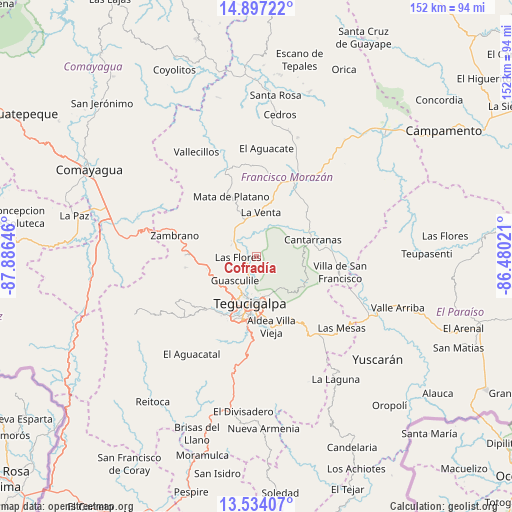
Cofradía GPS coordinates[2]
14° 13' 0.012" North, 87° 10' 59.988" West
| Map corner | latitude | longitude |
|---|---|---|
| Upper-left | 14.89722°, | -87.88646° |
| Center: | 14.21667°, | -87.18333° |
| Lower-right: | 13.53407°, | -86.48021° |
| Map W x H: | 151.6×151.6 km | = 94.2×94.2mi |
| max Lat: | 16.45° ⇑80.6% North |
| Cofradía: | 14.21667° |
| min Lat: | ⇓19.4% South 13.11667° |
| min Long | Cofradía | max Long |
| -89.23333° | -87.18333° | -83.23333° |
| W 67%⇐ | ⇒33% E |
Elevation
Elevation of Cofradía is 1131 m = 3711 ft, and this is 569.8 m = 1869 ft above average elevation for this country.
| Max E: |
1811 m = 5942 ft | 11.2% |
| Cofradía | 1131 m 3711 ft | |
| Avg. | 561.2 m = 1841 ft | |
Min E: |
1 m = 3 ft | 88.8% |
See also: Honduras elevation on elevation.city.
Geographical zone
Cofradía is located in North Torrid zone (between Equator and Tropic of Cancer). Distance of this Northern Tropic circle is 1025.2 km =637 mi to North.| Distance of | km | miles | from Cofradía |
|---|---|---|---|
| North Pole | 8426.3 | 5235.9 | to North |
| Arctic Circle | 5820.4 | 3616.6 | to North |
| Tropic Cancer | 1025.2 | 637 | to North |
| Equator | 1580.7 | 982.2 | to South |


Nearby cities:
15 places around Cofradía: (largest is in red/bold)
• El Chimbo
11.7 km =7.3 mi,  142°
142°
• El Durazno
12.9 km =8 mi,  224°
224°
• El Lolo
14.3 km =8.9 mi, 218°
• El Tablón
20.5 km =12.7 mi,  174°
174°
• El Terrero
20.9 km =13 mi, 142°
• Las Tapias
19.9 km =12.4 mi,  212°
212°
• Mateo
20.7 km =12.9 mi, 224°
• Río Abajo
6.6 km =4.1 mi, 212°
• San Juan de Flores
17.1 km =10.6 mi,  71°
71°
• San Juancito
12.6 km =7.8 mi,  90°
90°
• Santa Lucía
14.8 km =9.2 mi,  151°
151°
• Tegucigalpa
15.2 km =9.4 mi,  189°
189°
• Támara
17.8 km =11.1 mi,  245°
245°
• Valle de Ángeles
17.8 km =11.1 mi,  114°
114°
• Villa Nueva
21.1 km =13.1 mi, 165°
Sources, notices
• [Note1] Compared only with cities in Honduras existing in our database
• [Src1] Map data: © OpenStreetMap contributors (CC-BY-SA)
• [Src2] Other city data from geonames.org with taken over terms of usage.
• [Src3] Geographical zone / Annual Mean Temperature by Robert A. Rohde @ Wikipedia
