Támara geodata
Támara (Francisco Morazán) is a populated place; located in Honduras in America/Tegucigalpa (GMT-6) time zone. With population of 2,683 people, there are 131 cities with bigger population in this country. Compared to other cities in Honduras, 81.8% of cities are located further ↑North; 60.8% of cities are located further ←West and 94.8% of cities have lower elevation than Támara. Note1


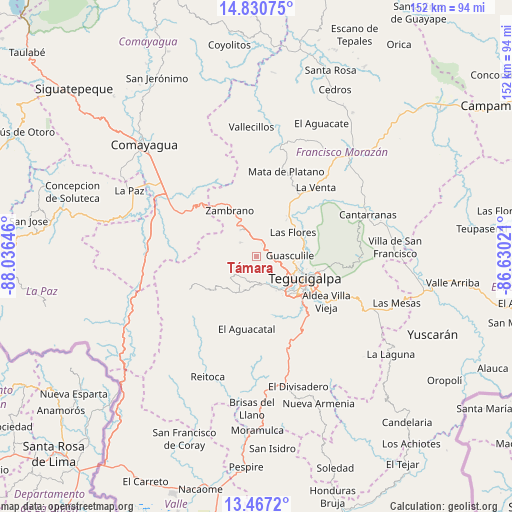
Támara GPS coordinates[2]
14° 9' 0" North, 87° 19' 59.988" West
| Map corner | latitude | longitude |
|---|---|---|
| Upper-left | 14.83075°, | -88.03646° |
| Center: | 14.15°, | -87.33333° |
| Lower-right: | 13.4672°, | -86.63021° |
| Map W x H: | 151.6×151.6 km | = 94.2×94.2mi |
| max Lat: | 16.45° ⇑81.8% North |
| Támara: | 14.15° |
| min Lat: | ⇓18.2% South 13.11667° |
| min Long | Támara | max Long |
| -89.23333° | -87.33333° | -83.23333° |
| W 60.8%⇐ | ⇒39.2% E |
Elevation
Elevation of Támara is 1304 m = 4278 ft, and this is 742.8 m = 2437 ft above average elevation for this country.
| Max E: |
1811 m = 5942 ft | 5.2% |
| Támara | 1304 m 4278 ft | |
| Avg. | 561.2 m = 1841 ft | |
Min E: |
1 m = 3 ft | 94.8% |
See also: Honduras elevation on elevation.city.
Geographical zone
Támara is located in North Torrid zone (between Equator and Tropic of Cancer). Distance of this Northern Tropic circle is 1032.6 km =641.6 mi to North.| Distance of | km | miles | from Támara |
|---|---|---|---|
| North Pole | 8433.7 | 5240.5 | to North |
| Arctic Circle | 5827.8 | 3621.2 | to North |
| Tropic Cancer | 1032.6 | 641.6 | to North |
| Equator | 1573.3 | 977.6 | to South |


Nearby cities:
15 places around Támara: (largest is in red/bold)
• Cofradía
17.8 km =11.1 mi,  65°
65°
• El Chimbo
23.4 km =14.5 mi,  94°
94°
• El Durazno
7.4 km =4.6 mi,  104°
104°
• El Lolo
8.1 km =5 mi,  117°
117°
• El Tablón
22.2 km =13.8 mi,  125°
125°
• El Tizatillo
22.4 km =13.9 mi,  138°
138°
• Las Tapias
10.7 km =6.6 mi,  149°
149°
• Lepaterique
17.1 km =10.6 mi,  237°
237°
• Mateo
7.6 km =4.7 mi,  166°
166°
• Ojojona
24.4 km =15.2 mi, 170°
• Río Abajo
12.7 km =7.9 mi,  81°
81°
• Santa Lucía
24 km =14.9 mi, 103°
• Tegucigalpa
15.6 km =9.7 mi, 119°
• Yaguacire
19.4 km =12.1 mi, 139°
• Zambrano
14.8 km =9.2 mi,  331°
331°
Sources, notices
• [Note1] Compared only with cities in Honduras existing in our database
• [Src1] Map data: © OpenStreetMap contributors (CC-BY-SA)
• [Src2] Other city data from geonames.org with taken over terms of usage.
• [Src3] Geographical zone / Annual Mean Temperature by Robert A. Rohde @ Wikipedia
