Strizivojna geodata
Strizivojna (Osječko-Baranjska) is a seat of a second-order administrative division; located in Croatia in Europe/Zagreb (GMT+2) time zone. With population of 2,771 people, there are 153 cities with bigger population in this country. Compared to other cities in Croatia, 64.8% of cities are located further ↑North; 88.6% of cities are located further ←West and 81.6% of cities have higher elevation than Strizivojna. Note1


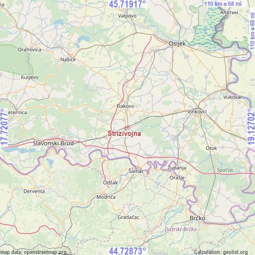
Strizivojna GPS coordinates[2]
45° 13' 33.996" North, 18° 25' 26.004" East
| Map corner | latitude | longitude |
|---|---|---|
| Upper-left | 45.71917°, | 17.72077° |
| Center: | 45.22611°, | 18.42389° |
| Lower-right: | 44.72873°, | 19.12702° |
| Map W x H: | 110.1×110.1 km | = 68.4×68.4mi |
| max Lat: | 46.52694° ⇑64.8% North |
| Strizivojna: | 45.22611° |
| min Lat: | ⇓35.2% South 42.54972° |
| min Long | Strizivojna | max Long |
| 13.52389° | 18.42389° | 19.37694° |
| W 88.6%⇐ | ⇒11.4% E |
Elevation
Elevation of Strizivojna is 84 m = 276 ft, and this is 69.3 m = 227 ft below average elevation for this country.
| Max E: |
827 m = 2713 ft | 81.6% |
| Avg. | 153.3 m = 503 ft | |
| Strizivojna | 84 m = 276 ft | |
Min E: |
-1 m = -3 ft | 18.4% |
See also: Croatia elevation on elevation.city.
Geographical zone
Strizivojna is located in North temperate zone (between Tropic of Cancer and the Arctic Circle). Distance of this North polar circle is 2372.5 km =1474.2 mi to North.| Distance of | km | miles | from Strizivojna |
|---|---|---|---|
| North Pole | 4978.4 | 3093.4 | to North |
| Arctic Circle | 2372.5 | 1474.2 | to North |
| Tropic Cancer | 2422.8 | 1505.5 | to South |
| Equator | 5028.7 | 3124.7 | to South |


Nearby cities:
15 places around Strizivojna: (largest is in red/bold)
• Beravci
8.3 km =5.2 mi,  176°
176°
• Budrovci
5.4 km =3.4 mi,  21°
21°
• Donji Andrijevci
10.6 km =6.6 mi,  246°
246°
• Gundinci
9.2 km =5.7 mi,  144°
144°
• Jaruge
12.3 km =7.6 mi, 181°
• Kuševac
13.5 km =8.4 mi,  1°
1°
• Piškorevci
3.6 km =2.2 mi,  334°
334°
• Sikirevci
13.4 km =8.3 mi,  166°
166°
• Stari Mikanovci
11.2 km =7 mi,  56°
56°
• Stari Perkovci
6 km =3.7 mi,  260°
260°
• Velika Kopanica
8.1 km =5 mi,  197°
197°
• Viškovci
13.6 km =8.5 mi,  12°
12°
• Vrpolje
2.2 km =1.4 mi,  219°
219°
• Čajkovci
5.8 km =3.6 mi,  233°
233°
• Đakovo
9.2 km =5.7 mi,  353°
353°
Sources, notices
• [Note1] Compared only with cities in Croatia existing in our database
• [Src1] Map data: © OpenStreetMap contributors (CC-BY-SA)
• [Src2] Other city data from geonames.org with taken over terms of usage.
• [Src3] Geographical zone / Annual Mean Temperature by Robert A. Rohde @ Wikipedia
