Čajkovci geodata
Čajkovci (Slavonski Brod-Posavina) is a populated place; located in Croatia in Europe/Zagreb (GMT+2) time zone. With population of 639 people, there are 717 cities with bigger population in this country. Compared to other cities in Croatia, 67.1% of cities are located further ↑North; 87.2% of cities are located further ←West and 80.6% of cities have higher elevation than Čajkovci. Note1


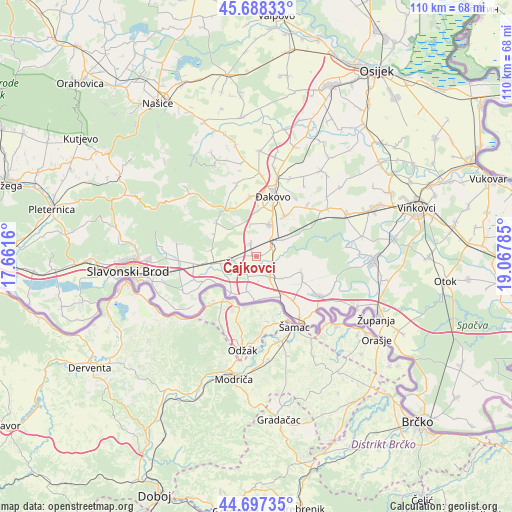
Čajkovci GPS coordinates[2]
45° 11' 42" North, 18° 21' 52.992" East
| Map corner | latitude | longitude |
|---|---|---|
| Upper-left | 45.68833°, | 17.6616° |
| Center: | 45.195°, | 18.36472° |
| Lower-right: | 44.69735°, | 19.06785° |
| Map W x H: | 110.2×110.2 km | = 68.5×68.5mi |
| max Lat: | 46.52694° ⇑67.1% North |
| Čajkovci: | 45.195° |
| min Lat: | ⇓32.9% South 42.54972° |
| min Long | Čajkovci | max Long |
| 13.52389° | 18.36472° | 19.37694° |
| W 87.2%⇐ | ⇒12.8% E |
Elevation
Elevation of Čajkovci is 85 m = 279 ft, and this is 68.3 m = 224 ft below average elevation for this country.
| Max E: |
827 m = 2713 ft | 80.6% |
| Avg. | 153.3 m = 503 ft | |
| Čajkovci | 85 m = 279 ft | |
Min E: |
-1 m = -3 ft | 19.4% |
See also: Croatia elevation on elevation.city.
Geographical zone
Čajkovci is located in North temperate zone (between Tropic of Cancer and the Arctic Circle). Distance of this North polar circle is 2376 km =1476.4 mi to North.| Distance of | km | miles | from Čajkovci |
|---|---|---|---|
| North Pole | 4981.8 | 3095.5 | to North |
| Arctic Circle | 2376 | 1476.4 | to North |
| Tropic Cancer | 2419.3 | 1503.3 | to South |
| Equator | 5025.2 | 3122.5 | to South |


Nearby cities:
15 places around Čajkovci: (largest is in red/bold)
• Beravci
7.1 km =4.4 mi,  133°
133°
• Budrovci
10.7 km =6.6 mi,  37°
37°
• Donji Andrijevci
5.1 km =3.2 mi,  261°
261°
• Gundinci
10.7 km =6.6 mi,  112°
112°
• Jaruge
9.8 km =6.1 mi,  153°
153°
• Oprisavci
11.7 km =7.3 mi,  245°
245°
• Piškorevci
7.4 km =4.6 mi,  24°
24°
• Sapci
12.5 km =7.8 mi, 261°
• Sikirevci
12.4 km =7.7 mi,  140°
140°
• Stari Perkovci
2.8 km =1.7 mi,  333°
333°
• Staro Topolje
9.2 km =5.7 mi,  266°
266°
• Strizivojna
5.8 km =3.6 mi,  53°
53°
• Trnava
11.4 km =7.1 mi,  310°
310°
• Velika Kopanica
4.9 km =3 mi, 152°
• Vrpolje
3.6 km =2.2 mi,  61°
61°
Sources, notices
• [Note1] Compared only with cities in Croatia existing in our database
• [Src1] Map data: © OpenStreetMap contributors (CC-BY-SA)
• [Src2] Other city data from geonames.org with taken over terms of usage.
• [Src3] Geographical zone / Annual Mean Temperature by Robert A. Rohde @ Wikipedia
