Sinj geodata
Sinj (Split-Dalmatia) is a seat of a second-order administrative division; located in Croatia in Europe/Zagreb (GMT+2) time zone. With population of 11,524 people, there are 36 cities with bigger population in this country. Compared to other cities in Croatia, 87.6% of cities are located further ↑North; 57.9% of cities are located further ←West and 91.6% of cities have lower elevation than Sinj. Note1


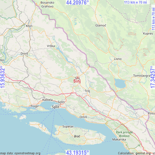
Sinj GPS coordinates[2]
43° 42' 12.996" North, 16° 38' 21.984" East
| Map corner | latitude | longitude |
|---|---|---|
| Upper-left | 44.20976°, | 15.93632° |
| Center: | 43.70361°, | 16.63944° |
| Lower-right: | 43.19315°, | 17.34257° |
| Map W x H: | 113×113 km | = 70.2×70.2mi |
| max Lat: | 46.52694° ⇑87.6% North |
| Sinj: | 43.70361° |
| min Lat: | ⇓12.4% South 42.54972° |
| min Long | Sinj | max Long |
| 13.52389° | 16.63944° | 19.37694° |
| W 57.9%⇐ | ⇒42.1% E |
Elevation
Elevation of Sinj is 322 m = 1056 ft, and this is 168.7 m = 553 ft above average elevation for this country.
| Max E: |
827 m = 2713 ft | 8.4% |
| Sinj | 322 m 1056 ft | |
| Avg. | 153.3 m = 503 ft | |
Min E: |
-1 m = -3 ft | 91.6% |
See also: Croatia elevation on elevation.city.
Geographical zone
Sinj is located in North temperate zone (between Tropic of Cancer and the Arctic Circle). Distance of this Northern Tropic circle is 2253.5 km =1400.3 mi to South.| Distance of | km | miles | from Sinj |
|---|---|---|---|
| North Pole | 5147.7 | 3198.6 | to North |
| Arctic Circle | 2541.8 | 1579.4 | to North |
| Tropic Cancer | 2253.5 | 1400.3 | to South |
| Equator | 4859.4 | 3019.5 | to South |


Nearby cities:
15 places around Sinj: (largest is in red/bold)
• Brnaze
2.8 km =1.7 mi,  162°
162°
• Gala
7.1 km =4.4 mi,  79°
79°
• Grab
11.7 km =7.3 mi,  122°
122°
• Greda
10.7 km =6.6 mi, 156°
• Hrvace
6.9 km =4.3 mi,  343°
343°
• Karakašica
3.5 km =2.2 mi,  356°
356°
• Košute
9.2 km =5.7 mi,  151°
151°
• Neorić
9.9 km =6.2 mi,  254°
254°
• Obrovac Sinjski
5.3 km =3.3 mi,  38°
38°
• Otok
7.8 km =4.8 mi,  104°
104°
• Potravlje
11 km =6.8 mi,  325°
325°
• Suhač
1.1 km =0.7 mi,  6°
6°
• Trilj
11.7 km =7.3 mi,  144°
144°
• Turjaci
6.4 km =4 mi, 158°
• Čeline
8.7 km =5.4 mi,  219°
219°
Sources, notices
• [Note1] Compared only with cities in Croatia existing in our database
• [Src1] Map data: © OpenStreetMap contributors (CC-BY-SA)
• [Src2] Other city data from geonames.org with taken over terms of usage.
• [Src3] Geographical zone / Annual Mean Temperature by Robert A. Rohde @ Wikipedia
