Hrvace geodata
Hrvace (Split-Dalmatia) is a seat of a second-order administrative division; located in Croatia in Europe/Zagreb (GMT+2) time zone. With population of 1,645 people, there are 261 cities with bigger population in this country. Compared to other cities in Croatia, 86.7% of cities are located further ↑North; 56.9% of cities are located further ←West and 93.9% of cities have lower elevation than Hrvace. Note1


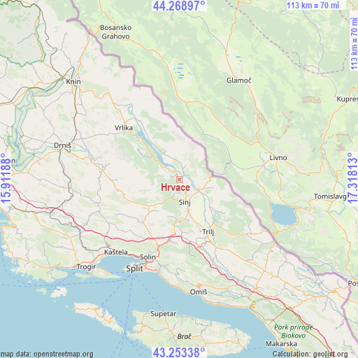
Hrvace GPS coordinates[2]
43° 45' 47.988" North, 16° 36' 54" East
| Map corner | latitude | longitude |
|---|---|---|
| Upper-left | 44.26897°, | 15.91188° |
| Center: | 43.76333°, | 16.615° |
| Lower-right: | 43.25338°, | 17.31813° |
| Map W x H: | 112.9×112.9 km | = 70.2×70.2mi |
| max Lat: | 46.52694° ⇑86.7% North |
| Hrvace: | 43.76333° |
| min Lat: | ⇓13.3% South 42.54972° |
| min Long | Hrvace | max Long |
| 13.52389° | 16.615° | 19.37694° |
| W 56.9%⇐ | ⇒43.1% E |
Elevation
Elevation of Hrvace is 357 m = 1171 ft, and this is 203.7 m = 668 ft above average elevation for this country.
| Max E: |
827 m = 2713 ft | 6.1% |
| Hrvace | 357 m 1171 ft | |
| Avg. | 153.3 m = 503 ft | |
Min E: |
-1 m = -3 ft | 93.9% |
See also: Croatia elevation on elevation.city.
Geographical zone
Hrvace is located in North temperate zone (between Tropic of Cancer and the Arctic Circle). Distance of this Northern Tropic circle is 2260.1 km =1404.4 mi to South.| Distance of | km | miles | from Hrvace |
|---|---|---|---|
| North Pole | 5141 | 3194.5 | to North |
| Arctic Circle | 2535.1 | 1575.2 | to North |
| Tropic Cancer | 2260.1 | 1404.4 | to South |
| Equator | 4866 | 3023.6 | to South |


Nearby cities:
15 places around Hrvace: (largest is in red/bold)
• Brnaze
9.7 km =6 mi,  163°
163°
• Gala
10.5 km =6.5 mi,  120°
120°
• Grab
17.5 km =10.9 mi,  137°
137°
• Greda
17.6 km =10.9 mi, 158°
• Karakašica
3.6 km =2.2 mi,  151°
151°
• Košute
16.1 km =10 mi, 156°
• Neorić
11.9 km =7.4 mi,  219°
219°
• Obrovac Sinjski
5.8 km =3.6 mi, 115°
• Otok
12.8 km =8 mi,  131°
131°
• Potravlje
5 km =3.1 mi,  298°
298°
• Ruda
16.9 km =10.5 mi, 126°
• Sinj
6.9 km =4.3 mi, 163°
• Suhač
5.9 km =3.7 mi, 159°
• Turjaci
13.3 km =8.3 mi, 160°
• Čeline
13.8 km =8.6 mi,  195°
195°
Sources, notices
• [Note1] Compared only with cities in Croatia existing in our database
• [Src1] Map data: © OpenStreetMap contributors (CC-BY-SA)
• [Src2] Other city data from geonames.org with taken over terms of usage.
• [Src3] Geographical zone / Annual Mean Temperature by Robert A. Rohde @ Wikipedia
