Radovin geodata
Radovin (Zadarska) is a populated place; located in Croatia in Europe/Zagreb (GMT+2) time zone. With population of 549 people, there are 812 cities with bigger population in this country. Compared to other cities in Croatia, 80.7% of cities are located further ↑North; 84.7% of cities are located further →East and 56.9% of cities have lower elevation than Radovin. Note1


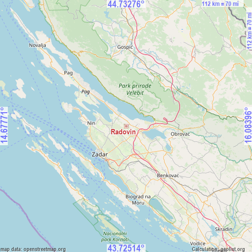
Radovin GPS coordinates[2]
44° 13' 51.996" North, 15° 22' 50.988" East
| Map corner | latitude | longitude |
|---|---|---|
| Upper-left | 44.73276°, | 14.67771° |
| Center: | 44.23111°, | 15.38083° |
| Lower-right: | 43.72514°, | 16.08396° |
| Map W x H: | 112×112 km | = 69.6×69.6mi |
| max Lat: | 46.52694° ⇑80.7% North |
| Radovin: | 44.23111° |
| min Lat: | ⇓19.3% South 42.54972° |
| min Long | Radovin | max Long |
| 13.52389° | 15.38083° | 19.37694° |
| W 15.3%⇐ | ⇒84.7% E |
Elevation
Elevation of Radovin is 139 m = 456 ft, and this is 14.3 m = 47 ft below average elevation for this country.
| Max E: |
827 m = 2713 ft | 43.1% |
| Avg. | 153.3 m = 503 ft | |
| Radovin | 139 m = 456 ft | |
Min E: |
-1 m = -3 ft | 56.9% |
See also: Croatia elevation on elevation.city.
Geographical zone
Radovin is located in North temperate zone (between Tropic of Cancer and the Arctic Circle). Distance of this Northern Tropic circle is 2312.1 km =1436.7 mi to South.| Distance of | km | miles | from Radovin |
|---|---|---|---|
| North Pole | 5089 | 3162.2 | to North |
| Arctic Circle | 2483.1 | 1542.9 | to North |
| Tropic Cancer | 2312.1 | 1436.7 | to South |
| Equator | 4918 | 3055.9 | to South |


Nearby cities:
15 places around Radovin: (largest is in red/bold)
• Briševo
9.7 km =6 mi,  218°
218°
• Crno
14.8 km =9.2 mi,  208°
208°
• Jesenice
15.7 km =9.8 mi,  90°
90°
• Kožino
16.2 km =10.1 mi,  245°
245°
• Murvica
10.4 km =6.5 mi, 205°
• Novigrad
14.8 km =9.2 mi,  110°
110°
• Podgradina
10 km =6.2 mi,  121°
121°
• Poličnik
5.9 km =3.7 mi,  184°
184°
• Posedarje
7.9 km =4.9 mi,  104°
104°
• Ražanac
6.2 km =3.9 mi,  335°
335°
• Slivnica
5.6 km =3.5 mi,  76°
76°
• Starigrad
8.6 km =5.3 mi,  32°
32°
• Suhovare
8.5 km =5.3 mi,  165°
165°
• Vrsi
12.4 km =7.7 mi,  287°
287°
• Zemunik Donji
13.8 km =8.6 mi, 180°
Sources, notices
• [Note1] Compared only with cities in Croatia existing in our database
• [Src1] Map data: © OpenStreetMap contributors (CC-BY-SA)
• [Src2] Other city data from geonames.org with taken over terms of usage.
• [Src3] Geographical zone / Annual Mean Temperature by Robert A. Rohde @ Wikipedia
