Primošten geodata
Primošten (Šibensko-Kniniska) is a populated place; located in Croatia in Europe/Zagreb (GMT+2) time zone. With population of 1,631 people, there are 264 cities with bigger population in this country. Compared to other cities in Croatia, 89.3% of cities are located further ↑North; 70.8% of cities are located further →East and 99% of cities have higher elevation than Primošten. Note1


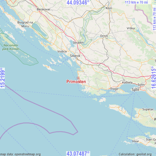
Primošten GPS coordinates[2]
43° 35' 10.752" North, 15° 55' 22.872" East
| Map corner | latitude | longitude |
|---|---|---|
| Upper-left | 44.09346°, | 15.2199° |
| Center: | 43.58632°, | 15.92302° |
| Lower-right: | 43.07487°, | 16.62615° |
| Map W x H: | 113.3×113.3 km | = 70.4×70.4mi |
| max Lat: | 46.52694° ⇑89.3% North |
| Primošten: | 43.58632° |
| min Lat: | ⇓10.7% South 42.54972° |
| min Long | Primošten | max Long |
| 13.52389° | 15.92302° | 19.37694° |
| W 29.2%⇐ | ⇒70.8% E |
Elevation
Elevation of Primošten is 2 m = 7 ft, and this is 151.3 m = 496 ft below average elevation for this country.
| Max E: |
827 m = 2713 ft | 99% |
| Avg. | 153.3 m = 503 ft | |
| Primošten | 2 m = 7 ft | |
Min E: |
-1 m = -3 ft | 1% |
See also: Croatia elevation on elevation.city.
Geographical zone
Primošten is located in North temperate zone (between Tropic of Cancer and the Arctic Circle). Distance of this Northern Tropic circle is 2240.4 km =1392.1 mi to South.| Distance of | km | miles | from Primošten |
|---|---|---|---|
| North Pole | 5160.7 | 3206.7 | to North |
| Arctic Circle | 2554.8 | 1587.5 | to North |
| Tropic Cancer | 2240.4 | 1392.1 | to South |
| Equator | 4846.3 | 3011.4 | to South |


Nearby cities:
15 places around Primošten: (largest is in red/bold)
• Bilice
22.8 km =14.2 mi,  350°
350°
• Brodarica
10.4 km =6.5 mi,  358°
358°
• Grebaštica
7.1 km =4.4 mi,  42°
42°
• Marina
16.8 km =10.4 mi,  118°
118°
• Primorski Dolac
21 km =13 mi,  76°
76°
• Rogoznica
7.8 km =4.8 mi,  151°
151°
• Seget Vranjica
22.9 km =14.2 mi,  111°
111°
• Sitno Donje
20 km =12.4 mi,  56°
56°
• Srima
20.2 km =12.6 mi,  332°
332°
• Tribunj
23.7 km =14.7 mi,  322°
322°
• Veliki Drvenik
23.8 km =14.8 mi,  129°
129°
• Vinišće
18.7 km =11.6 mi, 125°
• Vodice
22.4 km =13.9 mi, 329°
• Zaton
23.9 km =14.9 mi,  340°
340°
• Šibenik
15.7 km =9.8 mi, 354°
Sources, notices
• [Note1] Compared only with cities in Croatia existing in our database
• [Src1] Map data: © OpenStreetMap contributors (CC-BY-SA)
• [Src2] Other city data from geonames.org with taken over terms of usage.
• [Src3] Geographical zone / Annual Mean Temperature by Robert A. Rohde @ Wikipedia
