Vinišće geodata
Vinišće (Split-Dalmatia) is a populated place; located in Croatia in Europe/Zagreb (GMT+2) time zone. With population of 774 people, there are 616 cities with bigger population in this country. Compared to other cities in Croatia, 91.9% of cities are located further ↑North; 65% of cities are located further →East and 99% of cities have higher elevation than Vinišće. Note1


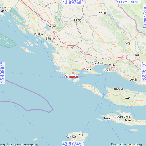
Vinišće GPS coordinates[2]
43° 29' 22.992" North, 16° 6' 47.016" East
| Map corner | latitude | longitude |
|---|---|---|
| Upper-left | 43.99768°, | 15.40994° |
| Center: | 43.48972°, | 16.11306° |
| Lower-right: | 42.97745°, | 16.81619° |
| Map W x H: | 113.4×113.4 km | = 70.5×70.5mi |
| max Lat: | 46.52694° ⇑91.9% North |
| Vinišće: | 43.48972° |
| min Lat: | ⇓8.1% South 42.54972° |
| min Long | Vinišće | max Long |
| 13.52389° | 16.11306° | 19.37694° |
| W 35%⇐ | ⇒65% E |
Elevation
Elevation of Vinišće is 2 m = 7 ft, and this is 151.3 m = 496 ft below average elevation for this country.
| Max E: |
827 m = 2713 ft | 99% |
| Avg. | 153.3 m = 503 ft | |
| Vinišće | 2 m = 7 ft | |
Min E: |
-1 m = -3 ft | 1% |
See also: Croatia elevation on elevation.city.
Geographical zone
Vinišće is located in North temperate zone (between Tropic of Cancer and the Arctic Circle). Distance of this Northern Tropic circle is 2229.7 km =1385.5 mi to South.| Distance of | km | miles | from Vinišće |
|---|---|---|---|
| North Pole | 5171.5 | 3213.4 | to North |
| Arctic Circle | 2565.6 | 1594.2 | to North |
| Tropic Cancer | 2229.7 | 1385.5 | to South |
| Equator | 4835.6 | 3004.7 | to South |


Nearby cities:
15 places around Vinišće: (largest is in red/bold)
• Donji Seget
10.2 km =6.3 mi,  72°
72°
• Kaštel Novi
19 km =11.8 mi, 69°
• Kaštel Štafilić
19 km =11.8 mi, 69°
• Marina
2.8 km =1.7 mi,  349°
349°
• Mastrinka
13.5 km =8.4 mi,  79°
79°
• Okrug Gornji
12.3 km =7.6 mi,  87°
87°
• Plano
14.7 km =9.1 mi, 65°
• Prgomet
16 km =9.9 mi,  35°
35°
• Primorski Dolac
16.5 km =10.3 mi,  17°
17°
• Primošten
18.7 km =11.6 mi,  305°
305°
• Rogoznica
12.2 km =7.6 mi,  288°
288°
• Seget Vranjica
6.4 km =4 mi, 69°
• Slatine
17.8 km =11.1 mi, 86°
• Trogir
11.5 km =7.1 mi, 77°
• Veliki Drvenik
5.3 km =3.3 mi,  145°
145°
Sources, notices
• [Note1] Compared only with cities in Croatia existing in our database
• [Src1] Map data: © OpenStreetMap contributors (CC-BY-SA)
• [Src2] Other city data from geonames.org with taken over terms of usage.
• [Src3] Geographical zone / Annual Mean Temperature by Robert A. Rohde @ Wikipedia
