Petrijanec geodata
Petrijanec (Varaždinska) is a seat of a second-order administrative division; located in Croatia in Europe/Zagreb (GMT+2) time zone. With population of 1,471 people, there are 308 cities with bigger population in this country. Compared to other cities in Croatia, 95.4% of cities are located further ↓South; 61% of cities are located further →East and 76.4% of cities have lower elevation than Petrijanec. Note1


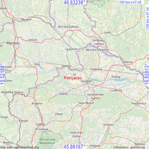
Petrijanec GPS coordinates[2]
46° 20' 57.012" North, 16° 13' 30" East
| Map corner | latitude | longitude |
|---|---|---|
| Upper-left | 46.83236°, | 15.52188° |
| Center: | 46.34917°, | 16.225° |
| Lower-right: | 45.86167°, | 16.92813° |
| Map W x H: | 107.9×107.9 km | = 67×67mi |
| max Lat: | 46.52694° ⇑4.6% North |
| Petrijanec: | 46.34917° |
| min Lat: | ⇓95.4% South 42.54972° |
| min Long | Petrijanec | max Long |
| 13.52389° | 16.225° | 19.37694° |
| W 39%⇐ | ⇒61% E |
Elevation
Elevation of Petrijanec is 184 m = 604 ft, and this is 30.7 m = 101 ft above average elevation for this country.
| Max E: |
827 m = 2713 ft | 23.6% |
| Petrijanec | 184 m 604 ft | |
| Avg. | 153.3 m = 503 ft | |
Min E: |
-1 m = -3 ft | 76.4% |
See also: Croatia elevation on elevation.city.
Geographical zone
Petrijanec is located in North temperate zone (between Tropic of Cancer and the Arctic Circle). Distance of this North polar circle is 2247.6 km =1396.6 mi to North.| Distance of | km | miles | from Petrijanec |
|---|---|---|---|
| North Pole | 4853.5 | 3015.8 | to North |
| Arctic Circle | 2247.6 | 1396.6 | to North |
| Tropic Cancer | 2547.6 | 1583 | to South |
| Equator | 5153.5 | 3202.2 | to South |


Nearby cities:
15 places around Petrijanec: (largest is in red/bold)
• Cestica
8.1 km =5 mi,  288°
288°
• Donje Ladanje
7.1 km =4.4 mi,  219°
219°
• Družbinec
0.1 km =0.1 mi,  350°
350°
• Gornje Ladanje
6 km =3.7 mi,  226°
226°
• Gornje Vratno
5.5 km =3.4 mi,  281°
281°
• Hrašćica
6 km =3.7 mi,  116°
116°
• Majerje
2.6 km =1.6 mi,  132°
132°
• Maruševec
7.4 km =4.6 mi,  205°
205°
• Marčan
6.3 km =3.9 mi,  249°
249°
• Nedeljanec
8.2 km =5.1 mi,  146°
146°
• Sračinec
4.7 km =2.9 mi, 117°
• Strmec Podravski
1.9 km =1.2 mi,  333°
333°
• Svibovec Podravski
4.4 km =2.7 mi,  79°
79°
• Vidovec
7.4 km =4.6 mi,  170°
170°
• Vinica
6 km =3.7 mi,  255°
255°
Sources, notices
• [Note1] Compared only with cities in Croatia existing in our database
• [Src1] Map data: © OpenStreetMap contributors (CC-BY-SA)
• [Src2] Other city data from geonames.org with taken over terms of usage.
• [Src3] Geographical zone / Annual Mean Temperature by Robert A. Rohde @ Wikipedia
