Cestica geodata
Cestica (Varaždinska) is a seat of a second-order administrative division; located in Croatia in Europe/Zagreb (GMT+2) time zone. With population of 504 people, there are 881 cities with bigger population in this country. Compared to other cities in Croatia, 96.5% of cities are located further ↓South; 64.3% of cities are located further →East and 78.3% of cities have lower elevation than Cestica. Note1


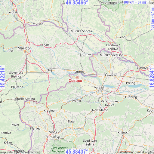
Cestica GPS coordinates[2]
46° 22' 18.012" North, 16° 7' 31.008" East
| Map corner | latitude | longitude |
|---|---|---|
| Upper-left | 46.85466°, | 15.42216° |
| Center: | 46.37167°, | 16.12528° |
| Lower-right: | 45.88437°, | 16.82841° |
| Map W x H: | 107.9×107.9 km | = 67×67mi |
| max Lat: | 46.52694° ⇑3.5% North |
| Cestica: | 46.37167° |
| min Lat: | ⇓96.5% South 42.54972° |
| min Long | Cestica | max Long |
| 13.52389° | 16.12528° | 19.37694° |
| W 35.7%⇐ | ⇒64.3% E |
Elevation
Elevation of Cestica is 193 m = 633 ft, and this is 39.7 m = 130 ft above average elevation for this country.
| Max E: |
827 m = 2713 ft | 21.7% |
| Cestica | 193 m 633 ft | |
| Avg. | 153.3 m = 503 ft | |
Min E: |
-1 m = -3 ft | 78.3% |
See also: Croatia elevation on elevation.city.
Geographical zone
Cestica is located in North temperate zone (between Tropic of Cancer and the Arctic Circle). Distance of this North polar circle is 2245.1 km =1395 mi to North.| Distance of | km | miles | from Cestica |
|---|---|---|---|
| North Pole | 4851 | 3014.3 | to North |
| Arctic Circle | 2245.1 | 1395 | to North |
| Tropic Cancer | 2550.1 | 1584.6 | to South |
| Equator | 5156 | 3203.8 | to South |


Nearby cities:
15 places around Cestica: (largest is in red/bold)
• Donja Višnjica
11.5 km =7.1 mi,  226°
226°
• Donja Voća
8 km =5 mi,  191°
191°
• Donje Ladanje
8.6 km =5.3 mi,  158°
158°
• Družbinec
8 km =5 mi,  107°
107°
• Gornja Voća
7.3 km =4.5 mi,  210°
210°
• Gornje Ladanje
7.4 km =4.6 mi,  153°
153°
• Gornje Vratno
2.6 km =1.6 mi,  121°
121°
• Klenovnik
12 km =7.5 mi,  200°
200°
• Majerje
10.5 km =6.5 mi, 114°
• Maruševec
10.2 km =6.3 mi, 154°
• Marčan
5 km =3.1 mi, 159°
• Petrijanec
8.1 km =5 mi, 108°
• Strmec Podravski
6.9 km =4.3 mi,  96°
96°
• Svibovec Podravski
12.1 km =7.5 mi, 98°
• Vinica
4.4 km =2.7 mi, 154°
Sources, notices
• [Note1] Compared only with cities in Croatia existing in our database
• [Src1] Map data: © OpenStreetMap contributors (CC-BY-SA)
• [Src2] Other city data from geonames.org with taken over terms of usage.
• [Src3] Geographical zone / Annual Mean Temperature by Robert A. Rohde @ Wikipedia
